Monday, November 30, 2009

Meteorological Winter Begins


UPDATE: You just lived through the 2nd warmest November on record. The average temperature at the Twin Cities Airport for the month was: 43.0 degrees, 10.3 degrees above average. We beat the previous 2nd warmest November of 41.8 degrees in 1999 by a decent margin, but couldn't crack the warmest November on record at 46.4 degrees in 2001.


Today will be the last day of our honeymoon/sabbatical as temperatures climb back into the 40's making it nearly a full month with seeing temperatures above average. We get back to reality tomorrow and Thursday as the first dump of colder air flushes in from the polar regions. Just in time too as we start meteorological winter today, marking (on average) the coldest three months of the year for us here in the Twin Cities.


December Headlines:


Average High Temperature
December 1st: 32 degrees
December 31st: 22 degrees
WARMEST: 68 degrees on December 1st, 1998

Average Low Temperature
December 1st: 17 degrees
December 31st: 6 degrees BRRR!
COLDEST: -29 degrees on December 19th, 1983

December is tied for the 3rd snowiest month along with November with and average of 10.0"
SNOWIEST December: 33.2" in 1969
SNOWIEST December Day: 12.0" on December 28th, 1982


Coldest of the Season So Far...
Click the image below to enlarge:
This image shows high temperatures on Thursday and winds around midday. Highs on Thursday will struggle to get into the 20's and winds will be out of the NW at 10 to 20mph with gusts of nearly 30mph dropping wind chill values into the teens and single digits at times!!


Wind chill chart for Thursday
I've highlighted the wind chill values for Thursday in the image below. This is what it'll feel like as you're hopping around town. It's about time to dig the heavy winter artillery out of the back of the closet if you haven't already.


Todd's Outlook for the Twin Cities


Today: Mildest day of the week, fading sun, still unseasonably mild. High: 43

Tonight: Increasing clouds and winds. Windows rattling late. Low: 27

Wednesday: Gusty and colder with a few flurries in the air. High: 32

Thursday: Breezy and feeling quite chilly. Lot's of clouds, a few flakes around. High: 24

Friday: Partly sunny, not as breezy, but still a few flakes. High: 24

Saturday: A few more peeks of sun, feeling like December. High: 28

Sunday: Partly cloudy. High 27

Sunday, November 29, 2009

Whoop - There It Is


Top ten warmest Novembers on record in the Twin Cities area looks like a shoe in this year. Top 5... Yep! The warmest... Not quite. We are currently sitting in the 2nd warmest Novembers on record slot and we're gonna be close to finishing there. The average temperature at the Twin Cities Airport is: 43.2 degrees, 10.2 degrees above average. The current 2nd warmest is 41.8 degrees in 1999 and the warmest is 46.4 in 2001.


Most Snow in a Long Time:

Doppler out of the Twin Cities early Sunday morning showed a band of snow moving through central Minnesota - the most we've seen on the radar in quite some time. Snow totals from Sunday's event are listed below.


 INCHES  LOCATION                 ST  COUNTY           TIME
------ ----------------------- -- -------------- -------
2.00 2 N CAMERON WI BARRON 0738 AM
2.00 6 NW RICE LAKE WI BARRON 0738 AM
1.50 CLAYTON WI POLK 0415 AM
1.30 2 SE CHETEK WI BARRON 0900 AM
1.20 2 SE CHISAGO CITY MN CHISAGO 0900 AM
1.20 5 NE FOREST LAKE MN CHISAGO 0738 AM
1.00 3 W LADYSMITH WI RUSK 0900 AM
1.00 1 SW BOYCEVILLE WI DUNN 0832 AM
0.90 JIM FALLS WI CHIPPEWA 0738 AM
0.60 STANLEY WI CHIPPEWA 0900 AM
0.60 HAMMOND WI ST. CROIX 0900 AM
0.50 3 SE LAKE ELMO MN WASHINGTON 0758 AM
0.20 1 W WOODLAND MN HENNEPIN 0900 AM
0.20 ROBERTS WI ST. CROIX 0900 AM
0.20 FARMINGTON MN DAKOTA 0900 AM
0.20 LONG PRAIRIE MN TODD 0900 AM

I felt a little foolish putting up holiday decorations this weekend. Second guessing myself, thinking maybe it's a little too early, too warm? Though, by looking around my neighborhood, I'm a little late keeping up with the Jones'. I had to turn on the XM radio, find the Christmas music, to help get in the holiday cheer. It's tough to get in the spirit when it doesn't look or feel like the holiday season. Temperatures will begin to wreak of early December by the end of the week. High temperatures will have a tough time getting into the 30's by Thursday with many locations staying in the upper 20's. The adjustment period begins as the coldest air of the season oozes out of Canada. Looking ahead, it may even be colder the 2nd week of December as a large low over Hudson Bay rotates cool air in from the Polar regions. Interestingly, the same storm that is bringing rain to southern California (ending San Diego's 4th longest stretch of dry weather 164 days! The longest was 182 days in 2004) will be the same storm that funnels the cold air into the northern tier states. Look here - watch the disturbance move from the southwestern part of the country to the Hudson Bay over the next 180 hours. It appears that the Low over the Hudson Bay will absorb the California Low by this weekend - interesting huh?


Next Chance of Snow

For the month of November so far, the Twin Cities Airport is 1.51" behind normal precipitation with only a trace of snow being reported, that is 9.7" behind normal snowfall for the month. Our next best chance of any moisture looks to remain along the international border and Arrowhead region - see animation here:

The image below shows the next clipper skipping across the international border Tuesday night/early Wednesday morning:


Todd's Outlook for the Twin Cities

Today: Partly sunny, a bit milder. High: 41

Tonight: Mostly cloudy. Quiet. Low: 30

Tuesday: Mildest day of the week, fading sun, still unseasonably mild. High: 44

Wednesday: Gusty and colder with a few flurries in the air. High: 32

Thursday: Unsettled, lot's of clouds, a few flakes around (probably no accumulation). High: 29

Friday: More sun, not as cold. High: 37

Saturday: Partly cloudy. High: 32

Saturday, November 28, 2009

An historic November

Weather Headlines

First snow-free November in 46 years for most of Minnesota, monthly temperatures 8-14 degrees above average.

Flurries this morning may dust a few lawns/roads, couple inches of snow predicted for far northern Minnesota by Thursday.

No heavy snow for central/southern Minnesota, but a real cold front is on the way for later this week.

Numbing first week of December, but temperatures may thaw out (temporarily) during the second week of December.

Statistical odds of a white Christmas for the Twin Cities? 71%

Unnecessarily Optimistic?
We're enjoying the first snow-free November since 1963, according to National Weather Service records. Temperatures across Minnesota are running 8-14 degrees above average, more typical of October than November. Although December will bring the first true outbreak of arctic air the CPC, the Climate Prediction Center, still has a warm bulls-eye directly over Minnesota for December, January and February, based on a strengthening El Nino event in the Pacific. We will see cold and snow, no question, but statistically: odds favor a somewhat milder than normal winter. That said, I still have my doubts. Only 2 out of 3 El Ninos wind up bringing warmer winters for Minnesota. I have a nagging feeling in the pit of my stomach that this winter may be the exception to the rule.


Normal Snow Cover as of November 28. According to long-term weather records the blue-shaded regions have a greater than 50% probability of snow by this date. For the reality...

Current Snow Cover as of November 28. To check this out for yourself (compare actual vs. normal snow cover around the globe click here to check out the Rutgers Global Snow Lab). Click on "daily" to see the latest snow conditions (and compare it with climatology).


Dig out the coats and parkas
: computer models pull the first true arctic slap into Minnesota by midweek (highs stuck in the 30s, some 20s central & north) with a reinforcing shot of even colder air arriving by next Sunday/Monday. A lack of (insulating) snow cover may increase the odds of pipes freezing up and bursting about one week out as nighttime lows dip into the teens, even some single digits up north. Hope I'm wrong on that call.
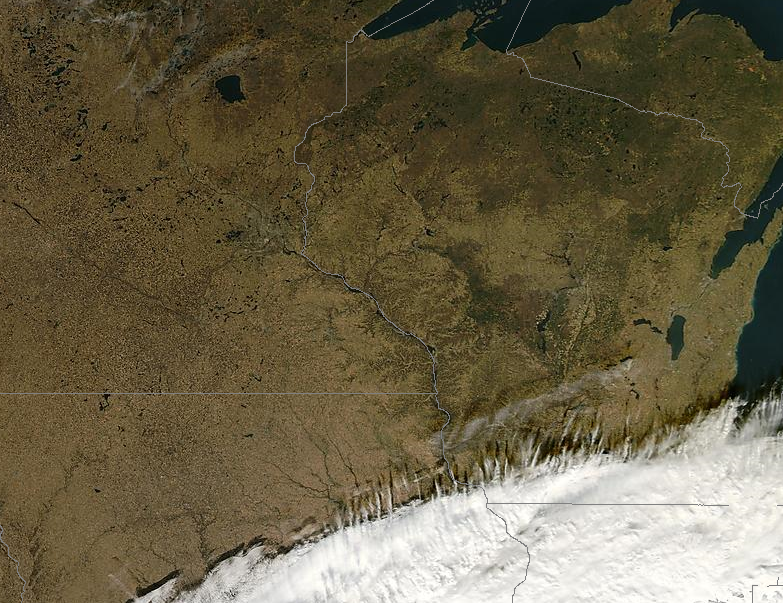
Where's the ice? Click the image to bring it full-screen, it's a high-resolution (visible) satellite image snapped by the low-orbiting NASA "Terra" weather satellite, roughly 250 miles above the earth. If you look carefully, squint a lot - you can make out a lack of ice, even over the Boundary Waters Canoe Area (the white squiggly line is the Minnesota/Canada border). No ice that far north in late November is highly unusual, almost unprecedented. To get the latest, ultra-high resolution satellite image (usually a 1 day delay) click here to see resolutions as high as 250 meters! The data and web site is courtesy of the University of Wisconsin.


46 degrees yesterday. Unbelievable. I'm black and blue from pinching myself all month. Yep, getting more odd stares than usual. We're in the midst of an historic November - no measurable snow to speak of as of November 28. At this rate we'll experience the first totally snow-free November since 1963, according to National Weather Service records. BTW, after no snow in November, '63, we went on to see just over 34" of snow for the entire winter. Click here to see a winter-by-winter, month-by-month recap for MSP since the winter of 1884-85. It's true that the official recording station has moved around during that period, from downtown St. Paul to downtown Minneapolis, to MSP International, then over to Chanhassen, where the local NWS office is located. That makes climatologists who study long-term trends a little nutty - shifting the weather instruments around from place to place, when what is truly prized and valued is continuity, consistency of record-keeping. There can be significant variations in temperature, wind, even moisture, from one part of the metro area to the next, so it's not the best scenario, but due to a number of factors, financial and political, the local NWS office has been forced to bounce around from time to time.

You may be surprised to hear me mention that (in my humble opinion) our mild, snow-free November is not PROOF of global climate change. When it gets really cold in December that won't be proof of anything either, other than the fact that we experience huge contrasts in day-to-day weather (only Siberia has more extremes in temperature and precipitation than we do, sitting close to the geographic center of North America). The recent uproar over leaked e-mails from a climate research center in the U.K. has provided fresh "evidence" for skeptics and deniers, they'll be feasting on this for months, maybe years. It's unfortunate, because it's another diversion, another distraction, another opportunity to put thousands of climate scientists on the defensive while greenhouse gases continue to accumulate, and changes (some quite dramatic) continue to play out, especially in the arctic regions.

If there was a cover-up of any kind, if data was concealed, changed or manipulated, then the scientists involved should pay a steep price (resign?) I'm a big believer in transparency, shining a bright light on all the science, make all of it public. The problem? A lot of arm-chair skeptics who know a thing about weather believe this automatically makes them experts on climate change. That's why some of these climate scientists are so defensive and angry in the first place. They're being repeatedly spammed, hounded, harassed and bullied by professional skeptics, many of them funded by various "institutes" that represent the oil, coal and gas industries maintaining the status-quo. Some of these targeted climate scientists made their displeasure known in these e-mail strings. I wouldn't like it either if I was being (digitally) stalked by a steady stream of deniers who have little interest in uncovering the "truth" when it comes to the state of the art of climate science.

Is there still a consensus among climate scientists that most of the observed warming is (mostly) man-made? Yes. Are things (apparently) getting worse, faster than even the IPCC predicted just a few years ago? Yes. Should ALL science be open, transparent and above petty bickering and obfuscation? Absolutely. The recent hacking of e-mails will probably change, perhaps profoundly, the way climate science is conducted and released to the public. Peer-review science needs to be above reproach, not subject to petty bickering or political posturing. If laws were broken the climate scientists involved should be prosecuted and reprimanded. Sadly, this all goes to perception. The public is already losing interest in climate change, even though 80% of the population still believes climate change is real, the percentage of people who believe it's the result of man-made activities is under 40% (and falling), and that's a very worrisome trend. The truth: for some deniers there will never be a critical mass of evidence to convince them. Ever. They've already made up their minds, and now they'll cherry-pick data that supports their (scientifically shaky) bully pulpit. If climate scientists start cherry-picking data to get the results they want, then God help us all - that would be an utter catastrophe. If the vast majority of reasonable, logical, fact-loving people who still believe there's a place in the world for science, if these consumers throw up their hands and give up on trying to understand what's happening all around them, well, then we're in for a very long & unpleasant 21st century. A certain amount of change is inevitable, based on what we've already pumped into the atmosphere. The question is whether we'll reach a true tipping point, a point of no return. Chances are your kids and grandkids will take this issue far more seriously than the current generation of baby-boomers. Just a hunch.

I wholeheartedly agree with George Monbiot's recent editorial in the U.K.'s Guardian newspaper, calling into question the climate scientists whose e-mail accounts were recently hacked. The data is out there, the genie is out of the bottle. No time to whine about invasion of privacy, better to explain what was said in those e-mails, and use this as an opportunity to shine a light on the science of climate change, making improvements in how this data is gathered, interpreted and ultimately explained to politicians and the general public. This is a teachable moment if there ever was one.

Interested in the science of climate change? Here is the Mother Lode of data from RealClimate.com: computer models, techniques and explanations. When I talk to people face to face I implore them to keep an open mind on this subject. The more you dig into the data, really drill down into the meat of the science of climate change, the more you'll see that this is not some global conspiracy, a new religion (as a Christian I find that charge more than a little insulting) or mass hypnosis - something is happening, something has changed, and the sooner we take action, the better the outlook for future generations.

The "Copenhagen Diagnosis" is being released in advance of next month's global conference. Here are a few of the "highlights" from the report. What's that old saying, "while Nero fiddled Rome burned..." While we turn climate change into fodder for shouting talking heads on TV and incendiary blog posts, the planet continues to warm, the weather continues to veer toward the extreme (just ask flooded residents in the U.K, cleaning up from some of the worst flooding in a millenia). And we just sit here, twiddling our thumbs, pointing fingers, waiting, wondering, screaming at each other, ultimately hoping for the best. Think anthropogenic climate change is all a bunch of baloney, an excuse for Al Gore to get rich, etc etc? Stay tuned - it's going to get very interesting, and within our lifetime.

A few highlights from the report:

— Greenhouse gas emissions are skyrocketing despite attempts to control them.

— Summertime melting of Arctic sea ice is 40 percent greater than forecast.

— Global sea level rise is 80 percent above past expectations and likely will continue for centuries.

“Many climate indicators have been tracking along the upper edge near the worst case scenario,” said Richard Somerville, a climate researcher at Scripps, which is part of the University of California, San Diego. “

“The Copenhagen Diagnosis” is the work of 26 researchers from around the world, most of whom have authored portions of landmark reports for the Intergovernmental Panel on Climate Change. In early 2007, that organization gained worldwide attention when 3,700 affiliated scientists said humans almost certainly are causing climate change. Click here for more details on the Copenhagen Diagnosis.

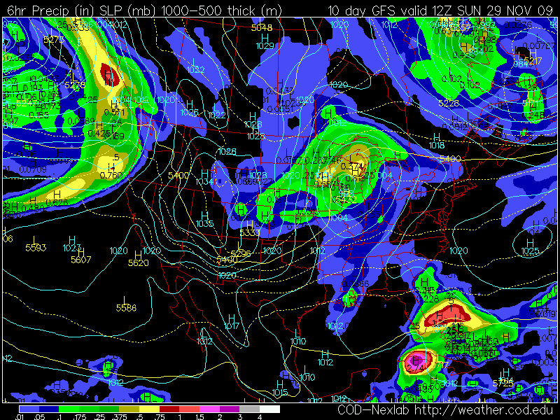
Potential for a few inches of snow up north. Relatively weak cold frontal passages today and again Wednesday may spark a few inches of wet snow for far northern Minnesota later this week (this map goes through midday Thursday) but I don't see any accumulating snow for St. Cloud or the Twin Cities through the end of the week. As long as winds aloft blow from the west/northwest we'll be hard-pressed to see a blanket of white. For a real snowy drubbing winds aloft need to blow from the southwest, from New Mexico and Texas, allowing Gulf moisture to surge north. I don't see that specific scenario....yet.

Paul's Outlook for the Twin Cities

Today: Partly to mostly cloudy with a cool breeze - best chance of flurries comes this morning. Winds: NW 10-15. High: 36

Tonight: Patchy clouds, seasonably chilly. Low: 28

Monday: Partly sunny, a bit milder. High: 41

Tuesday: Mildest day of the week, fading sun, still unseasonably mild. High: 44

Wednesday: Gusty and colder with a few flurries in the air. High: 32

Thursday: Unsettled, lot's of clouds, a few flakes around (probably no accumulation). High: 29

Friday: More sun, not as cold. High: 37

Saturday: Clouds increase, windy and colder again with more flurries (best chance north). High: 32

Thursday, November 26, 2009

Turkey hangover

The ongoing debate/firestorm over the recent hacking of climate-related e-mails has lead me to post a few thoughts and responses I've sifted through in recent days, for better or worse. Here goes...

"As a sociologist, I can't imagine what's so unusual about these emails. Science is messy. The brilliance of science as a system isn't its individual findings, but rather how their iterations function as a whole to produce general truths. This is because SCIENCE IS MESSY.

Before deciding to hop on the academic track, I used to be a carpenter. Guess what? Carpentry is messy too. Life is messy. At the end of the day, despite countless dismays, and conversations about how this house will never stand, none of the houses I ever built came crashing down. Why? Because there are a lot of nails and joints in there, and one piece cut too big or too small doesn't make a whole heck of a lot of difference in the end."

- anonymous

From Peter Watts, scientist and author:

"Science doesn’t work despite scientists being asses. Science works, to at least some extent, because scientists are asses. Bickering and backstabbing are essential elements of the process. Haven’t any of these guys ever heard of “peer review”?

"That’s how science works. It’s not a hippie love-in; it’s rugby.

"This is how it works: you put your model out there in the coliseum, and a bunch of guys in white coats kick the shit out of it. If it’s still alive when the dust clears, your brainchild receives conditional acceptance. It does not get rejected. This time."

"As for me, I’ll follow the blogs with interest and see how this all shakes out. But even if someone, somewhere, proves that a handful of climatologists deliberately fudged their findings — well, I’ll be there with everyone else calling to have the bastards run out of town, but it won’t matter much in terms of the overall weight of the data. I went running through Toronto the other day on a 17°C November afternoon. Canada’s west coast is currently underwater. Sea level continues its 3mm/yr creep up the coasts of the world, the western Siberian permafrost turns to slush. Swathes of California and Australia are pretty much permanent firestorm zones these days. The glaciers retreat, the Arctic ice cap shrinks, a myriad migratory species still show up at their northern destinations weeks before they’re supposed to. The pine beetle furthers its westward invasion, leaving dead forests in its wake— the winters, you see, are no longer cold enough to hit that lethal reset button that once kept their numbers in check.

I could go on, but you get my drift. And if the Climate-Change Hoax Machine is powerful enough to do all that, you know what?

They deserve to win."

- Peter Watts (his complete post regarding "email-gate" can be found here).


I received a couple of e-mails from climate change deniers positively giddy about the recent hacking of e-mails from scientists at the University of East Anglia's Climate Research Unit. For people who consistently doubt the veracity of the science surrounding anthropogenic climate change this was the "smoking gun" many had been waiting for, seeming to PROVE that a handful of scientists were secretly plotting and scheming, "manipulating the numbers" to skew the science in favor of man-made climate change. But a closer inspection of the e-mails shows something much less dramatic: that science is inherently messy (because scientists are - surprise! - just as human as the rest of us). They bicker, complain, compete, gossip and vent occasional bursts of rage at professional deniers intent on interfering with their research. I find the timing of all this very curious: with a global climate change summit at Copenhagen just a few weeks away. My hope is that this [pr mess] will shine a bright light on the huge and growing body of science, the mountain of mounting evidence, that people will look at this topic with fresh eyes. My fear is that this will only increase the decibel level of the shouting underway, entrench the skeptics and further embolden the conspiracy theorists who see deception under every rock. The evidence is there, for people truly willing to look. It's easier to follow incendiary blogs and TV talking points than it is to truly sift through the science and assess the evidence objectively. All of us bring along our own biases, even scientists. But when scientists are wrong their peers, their competitors, take JOY in pointing out their mistakes and errors. As you'll see below, science is messy, but the PROCESS eventually comes up with truth, however impermanent. Isaac Newton was a complete jackass (from what I've read) but his theory of gravity still holds up pretty well. His theory has stood the test of time - and the scientific method. For those who see these leaked e-mails as evidence of a vast conspiracy all I can say is be patient. Only time will tell if climate change science is the "hot air" skeptics believe it to be. To those who still doubt, all I can say is be prepared for more unpleasant symptoms, bizarre storms, floods, droughts, super-hurricanes and climate oddities in the years ahead. This is a slow-motion transformation, but the paradox remains: by the time the last piece of the (climate) puzzle falls into place it will be far too late to do anything about it. We'll have no choice but to adapt, take it on the chin. I hope we come to our senses before we reach that inevitable "tipping point", but I'm no longer optimistic we'll be able to save ourselves (from ourselves).

For more information on this hacked e-mail tempest in a teapot, including 60 mb worth of leaked e-mail text (most of it mind-numbingly dull) click here for a long, detailed post from boingboing.com's Maggie Koerth-Baker. If you're looking for more ammunition, a point-by-point refutation of all the claims and counterclaims dredged up by persistent deniers, click here to read "How to talk to a climate change skeptic" at scienceblogs.com.

So much for the increasingly partisan, angst-ridden subject of climate change. Let's shift gears and focus on weather, which may or may not be safer ground, something almost all of us can agree on. BTW, our record-warm November is not, necessarily evidence of climate change. One month doesn't prove anything (even though we're seeing temperatures more than 10 degrees above average, even though November is turning out to be warmer than all of October!) One month does-not-a-trend-make. This is weather, not climate. It's true that Novembers are trending warmer, with less snow, the past 10 consecutive Novembers warm enough to play golf. Ask your grandfather how often he got out to play golf in November when he was growing up. One storm, one week, one month, even an entire season or year doesn't prove anything. What's critical is not what's happening over Minnesota, but the global snapshot, over many years - decades. All of us are armchair experts on weather, the day to day fluctuations and variations. Few of us possess the tools to be able to monitor the entire planet over a long period of time, objectively, comprehensively. I rely on the thousands of PhD climate scientists worldwide who do this for a living. In this crowd, in spite of what you may have read, there is still widespread agreement that the changes are real, happening even faster than the latest 2007 IPCC report predicted across in northern latitudes and polar regions. Sorry, I'll throw my hat in with these guys and gals until a better theory comes along to explain what we're witnessing on a planetary scale.

We salvaged a pretty nice Thanksgiving, peeks of sun filtering through high clouds Thursday afternoon. The 1-2" of slushy snow that piled up Wednesday near Wadena is already gone, no more accumulating snow is in sight through the middle of next week, no massive post-Thanksgiving slopstorms to contend with for the drive or flight home, I'm happy to report.
Our weather will be dominated by strong jet stream winds aloft, meaning rapid changes, with a definite return to "average" temperatures for late November and early December. We expect minor warm-ups today, Saturday, again Monday, followed by a strong surge of chilly air most of next week. This outbreak of Canadian air will shove the main storm track well south of Minnesota, with significant rain predicted for much of the south and east over the next 7-10 days. But I see little or now precipitation, rain, ice or snow, through the first weekend of December. The arrival of colder air may set off a few snow flurries up north Sunday, anther, even colder front arriving Tuesday with blustery winds and a fistful of flurries, but I don't see anything sticking on the ground through the first 10 days or so of December.

Do you realize we'll probably go through the entire month of November with NO MEASURABLE SNOW? I'm checking with Pete Boulay at the State Climatology Office to see when the last time that happened. Considering we normally pick up 8-10" of snow in November this is (stating it mildly) highly unusual. The last time we saw no snow in November? 1963. Somehow I don't think we'll be quite so lucky (or unlucky - if you happen to like snow) in December.

By the way, 18 years ago the Twin Cities was buried under nearly 47" in November of 1991. Yes, that was the year of the Halloween Superstorm. Brings back some warm & fuzzy memories huh?

Good luck with your shopping expedition. Be careful out there!

Paul's Outlook for the Twin Cities

Today: Plenty of sunshine, breezy, mildest day in sight. Winds: S/SE 10-15. High: 46

Tonight: Partly cloudy, chilly. Low: 29

Saturday: Intervals of sun, turning breezy and cooler. Winds: NW 10-20. High: 44

Sunday: More clouds than sun, a passing flurry or two. High: 36

Monday: Partly cloudy, still storm-free. High: near 40

Tuesday: Another cold front arrives, gusty, turning colder with a few flurries. High: 39

Wednesday: Mostly cloudy, "average" temperatures for early December. High: near 34

Thursday: Feels like winter, colder than normal with patchy clouds and flurries. High: near 30

Wednesday, November 25, 2009

Outlook: leftovers

I've just been handed the latest forecast: turkey will accumulate 1-3" on area plates, some salting may be necessary. Be on the lookout for massive mashed potato drifts, showers of scalding gravy; cranberry sauce will leave some side dishes slippery. Expect thunderous growls - of indigestion. A Tums Watch has been issued for the entire area, expect sporadic napping after 5 pm, with a 45% probability of a football game. I stand by this forecast, there's even a chance I'll get it right.

Add weather to a long list of things to be thankful for this year, the maps continue to look more like late October than late November, no major travel-busting snow or ice storms showing up anywhere. Yesterday's cold rain is pushing east into the Great Lakes, the arrival of chilling air arriving a few hours too late for any accumulating snow across most of Minnesota. You'll notice a long-lost sting in the air today, daytime temperatures stuck in the 30s with a morning wind chill dipping into the teens. But the sun will come out, dry weather prevailing into Saturday across the Upper Midwest. Good timing. Friday still looks like the mildest day in sight, with highs poking into well into the 40s as winds shift around to the south. Sunshine starts to fade a bit Saturday, the arrival of cooler air setting off a few flurries Sunday (mainly over the northern half of Minnesota). We warm up again early next week before a colder front knocks temperatures back down to average the latter half of next week. A southern storm forecast to track toward the Great Lakes may brush parts of Minnesota with a little light snow next Thursday and Friday, but at this point in time I don't see any major storms in sight through the first week to 10 days of December.


* So far the first 26 days of November the average temperature in the Twin Cities (factoring highs and lows) is 44.55 degrees F, that's 10.5 degrees warmer than average. The first 26 days of November have been WARMER THAN ALL OF OCTOBER, when the average temperature was a brisk 43.2 F. Amazing.

A Minor Correction. Yes, temperatures are cooling a bit, but considering that the average high is now close to freezing, the mercury will continue to trend 5-10 degrees above average through much of next week.

Remarkably Snow-Free. Remember how unusual our snow drought is: November is (on average) the THIRD snowiest month of the year, with an average of 8-10" of snow by the end of the month. The GFS model is hinting at a couple of inches of snow for the Appalachian Mts. and interior New England - otherwise precious little accumulating east of the Rockies. Snowmobilers and skiers: be patient. Our time will come.

There's little doubt that December will start out without any hint of Indian Summer - for now the 50s and 60s are behind us, we'll be lucky to salvage af few more 40-degree days over the next 2 weeks. That said, November has been a meteorological bargain: NO SNOW (we should have seen 8" as of November 6, we've picked up zero accumulating snow so far). In spite of the return of cooler, more seasonable weather, November temperatures are averaging 10.4 degrees above normal. That's very significant statistically, more than making up for a chilly October. Will the warmth hang on the entire winter? Will El Nino save us? I'm still banking on a "slightly milder" than average winter, based on recent trends and the growing stain of warmer water in the equatorial Pacific. Would I bet the farm on that prediction?

Absolutely not.


November so far in the Twin Cities. Here is is, day by day, courtesy of the National Weather Service in Chanhassen. Factoring in daily highs and lows November temperatures are 10.5 degrees above average. Only .25" of rain has fallen, 1.37" less than normal, to date. No official snowfall for the month as of November 26? Amazing.

Paul's Outlook for the Twin Cities

Today: Cool breeze, patchy clouds early, then partly sunny and brisk. Winds: NW 10-15. High: 38

Tonight: Mostly clear, frosty. Low: 26

"Black Friday". Fine weather for cooling off your credit cards: plenty of sun, breezy & milder. High: 47

Saturday: Fading sun, still dry - good travel conditions. High: 44

Sunday: More clouds, a few passing flurries (best chance over northern MN). High: 38

Monday: Mix of clouds and sun - chilly again. High: 34

Tuesday: Breezy and milder, fading sun. High: near 42

Wednesday: Gusty and colder with flurries in the air. High: 34

Tuesday, November 24, 2009

First snowfall in 44 days

Do you realize that (before today) there was NO SNOW reported in St. Cloud during the entire month of November? That's pretty amazing, when you consider that (during an average November) about 8-9" of snow piles up across central Minnesota. The last time we had measurable snow was October 12, when 2.5" fell (chances are you remember that quite vividly). We've had a month devoid of not only snow, but wind chill - an unusual amount of sunshine for what is (historically) the cloudiest, gloomiest month of the entire year. Add weather to a long list of things to be thankful this year. Residents of the U.K. are grappling with a new storm, more rain falling on waterlogged soil, residents still trying to clean up from an historic deluge. In Cumbria (northwestern England, the wettest region in the U.K.) some towns reported over a foot of rain in 24 hours, the most extreme rains in nearly a thousand years, according to local climatologists. For more information on these incredible floods check out a blog from Mark Vogan, a weather enthusiast in Scotland who I met when I was working for 'CCO. He has an amazing recap of the epic flooding here.

For the first time since October 12 we expect some "accumulating snow" in the St. Cloud area today. On my scale (which I borrowed from a favorite college professor) from "nuisance" to "plowable" to "crippling" this still looks a minor snowfall, probably at the upper end of the "nuisance" scale.....just enough slush to stare out your window later on and see the lawn whiten up. We may still wake up to anywhere from a coating to an inch of slushy snow Thanksgiving morning. If you're up early (before 8 or 9 am - yep, that's still "early" for yours truly) you may run into some slippery spots, but many roads will be wet, with temperatures just below the freezing mark. As far as travel today is concerned, a few headlines:

1). The earlier you hit the highways today, the better. Temperatures will fall through the 30s during the day, roads mostly-wet through the midday and afternoon hours. By the time temperatures reach freezing (late afternoon/evening) MOST of the moisture will be pushing to our east, into Wisconsin. But I could still see some icy/slippery roads anytime after 4 or 5 pm.

2). Since the sun sets early now (around 4:30 pm) we'll quickly lose whatever invisible infrared radiation the sun can provide. My hunch is that the drive home will be tougher & slower than the drive in this morning.

3). If you leave this evening/tonight expect slushy/icy roads, especially the side streets and secondary roads. My hunch is that major freeways, county and state roads will stay mostly-wet. MnDot should be prepared and put down their salt/sand mixture during the day.


A "Nuisance" Snowfall. The latest (NAM) model is predicting only a coating to 1" of slushy snow today and tonight for much of Minnesota, just over 1" for southeastern towns, including Rochester, Canon Falls and Winona. As much as 2-4" may pile up closer to the storm track, over southwestern Wisconsin. Keep in mind (in light of recent warmth) ground temperatures are still relatively warm, snow will melt-on-contact for a period of time today, by the time it's cold enough for snow to stick on lawns, fields and highways the bulk of the moisture will be to our east.

Predicted Weather Conditions for 1 pm Today. This National Weather Service forecast graphic shows a band of heavier wet snow from the Twin Cities south/southwest to Mankato, Glencoe and Fairmont, with a mix of rain/snow for western Wisconsin and southeastern Minnesota. Lighter snow is predicted for central/western/northern counties, including St. Cloud and Brainerd.

Predicted Weather Conditions for 7 pm Today. Light to moderate snow is predicted over the MN Arrowhead, western Wisconsin, and the counties just south/east of the Twin Cities.


Paul's Outlook for the Twin Cities

Today: A light rain/snow mix changing over to mostly snow by afternoon. Winds: NW 10-20+ High: 39 (early), falling to about 32 by 6 pm. Roads will become slushy and potentially slippery by late afternoon and evening. Plan on a very slow PM commute.

Tonight: Light snow tapering to flurries, potential for a coating to 1" of slushy snow, mainly on lawns and fields, but some roads will become icy. Potential for 1-2" far southeastern MN. Low: 29

Thanksgiving Day: Morning clouds, a few flurries (early). They partly sunny by afternoon. Winds: NW 10-15. High: 36

Friday: Fine weather for shopping (and digesting). Plenty of sun, a bit milder. High: 41

Saturday: Nicer day of the weekend, fading sun as clouds increase - still dry. High: 43

Sunday: A little light snow and flurries - potential for a dusting/coating. Some roads may become slick. High: 37

Monday: Flurries taper, partial clearing - temperatures closer to average for late November. High: 35

Tuesday: A mix of clouds and sun, seasonably chilly. High: 33

Monday, November 23, 2009

Weather menu: Thanksgiving slush

October was one of the 5 coolest on record, according to climatologists at NCDC, the National Climactic Data Center in Asheville, North Carolina. November is trending much warmer than average (that hardly comes as a headline) but I was intrigued to see a global snapshot of temperatures worldwide since January 1. Granted, 9 months does-not-a-trend-make, but you don't have to be a rocket scientist to see that, across the entire planet, temperatures are trending warmer than the long-term average. We're on track to see the 5th warmest year, worldwide, since 1880 (in spite of consistently cooler temperatures for the northern tier states of the USA). Again, it's so tempting to look out the window and ASSUME that this is what everyone is experiencing. Keeping that true (global) perspective is problematic, even for seasoned meteorologists. There's still lingering confusion between "weather" (ie CNN Headline News) and "climate" (ie the History Channel). October's chill was an example of weather, so is our mild November, for that matter. You really have to step back and examine trends over decades to reach any conclusions about climate trends. The bottom line: even though Minnesota experienced a somewhat cooler summer (with fewer tornadoes!) and October was unseasonably chilly, the global trend has still been one of consistent warming, not just 2009, but a steady upward trend in temperature since the early 80s. Have temperatures leveled off a bit since 1998? Yes. But there is absolutely no sign of "global cooling" or any other data points that would suggest climate scientists are colluding, plotting or scheming to skew the data in any way, at least none that I can find. There will always be conspiracy theorists, and people who just don't want to face the (potentially unpleasant) facts, some politicians will always cherry-pick data and try to do their spinning, but the next time it snows (and it will), or the next time you squeeze into a parka, muttering about "that damn global warming" under your breath, remember it's weather, not climate. To get a grip on what's truly happening, planet-wide, try to keep that (global), long-term perspective. I know - easier said than done.


No sign of "global cooling". This is snapshot of temperature departures from normal since January 1, for the entire planet. The blue dots represent cooler-than-average, the red dots show warmer-than-average readings. The larger the dot the greater the departure from normal. The data is stunning: yes, the northern tier states of the USA have been cooler than normal, but the rest of the planet is trending significantly warmer than the long-term average (since 1880), according to NCDC, the National Climatic Data Center, a division of NOAA. As of October 2009 is the 5th warmest year on record, the average global temperature a little more than 1 degree F warmer than average, but across much of Africa, Asia and northern Russia/Siberia temperatures are trending as much as 3-5 degrees F above average. [I know, there's a typo in the title of the graphic, it should read "Temperature Anomalies" - nothing I can do about that. Yes, even the government makes mistakes.] For more details click here.


I still think we'll wake up to a white Thanksgiving - but there's no cause for panic-in-the-streets. The bulk of precipitation with this latest storm will continue to fall as rain, through the day today and tonight. But tomorrow as all levels of the atmosphere begin to cool down I still expect a changeover to wet snow. During the day there may be a little slushy accumulation on some lawns and fields (roads should stay wet during the daylight hours Wednesday with temperatures staying above freezing). But after sunset tomorrow, after 4-5 pm, give or take, some of that slushy snow may start to stick, especially on secondary roads and side streets. By the time it's cold enough for snow MOST of the moisture will be south/east of town, we're talking 4-8 hours of light snow at the tail-end of this storm, most of it coming Wednesday evening/night. How much? Best bet is under 1", although I could still envision as much as 1-3" across western Wisconsin and parts of southeastern Minnesota, closer to this "cold core low" sliding off just to our south and east. With temperatures falling into the upper 20s Wednesday night many roads will become slushy and slick, and I think many of us will wake up to a coating of slush Thanksgiving Day. Much of the snow will melt during the day Thursday, roads mainly-wet after 9 or 10 am. If you're out Wednesday night or FIRST THING Thanksgiving Day you will probably encounter some slippery roads. But getting around from midday Thursday into Saturday should be just fine as skies slowly clear and temperatures moderate a bit, reaching well into the 40s again Saturday (the nicer, brighter/drier day of the weekend). A reinforcing cold front squeeze out a few hours of very light snow and flurries on Sunday (a coating of slush can't be ruled out with highs close to freezing). No heavy snow accumulations are imminent, but within 24-36 hours there will be NO doubt in your mind that it's late November. It was nice while it lasted, but now it's time to face reality. Ugh.


Air pollution in late November? According to the Minnesota Pollution Control Agency (MPCA) the air over much of Minnesota and western Wisconsin is unhealthy, a temperature inversion (warmer air aloft) trapping pollutants at ground level. Dense fog has been reported over the MN Arrowhead and much of Wisconsin. People with risk factors (lung/heart conditions) may want to consider cutting down on strenuous outdoor activities today - a rush of colder air will break up the inversion tomorrow as rain mixes with, and eventually changes over to a period of wet snow.


Thanksgiving Day Weather (courtesy of the MN State Climate Office)

Because Thanksgiving Day occurs at the transition period between autumn and winter, Thanksgiving weather can be balmy to brutal. A typical Thanksgiving Day in the Twin Cities has high temperatures in the 30's and at least a bit of filtered sunshine.

Having a mild day in the 50's on Thanksgiving Day is relatively rare, looking at the historical record back to 1891. A maximum of 50 or more has happened only nine times in 115 years, or about once every 13 years or so. The warmest Thanksgiving Day is a tie of 62 degrees set in 1914 and 1922. The mildest recent Thanksgiving Day is 58 degrees on November 26, 1998.

On the other side of the spectrum, it is common to have a high temperature below 32. The average Thanksgiving Day temperature is right around freezing. What about extremely cold Thanksgivings? It is about as likely to have a minimum at or below zero on Thanksgiving Day, as it is to have a maximum of 50 or above. It has occurred eight times in the past 115 years. The coldest Thanksgiving Day temperature is eight degrees below zero. This has happened three times, 1893, 1905 and 1985.

Measurable snow fell on 25 of the past Thanksgivings back to 1891, about every five years or so. The most snow that fell on Thanksgiving was five inches in 1970.

Historically, about one in three Thanksgivings have at least one inch of snow on the ground. The deepest snow pack is a tie with 1921 and 1983, both with 10 inches on the ground by Turkey Day.

It occasionally rains on Thanksgiving Day as well. In 1896, a two-day event in the Twin Cities doused Thanksgiving travelers with nearly three inches of rain.

To check out Thanksgiving Day weather, year by year (since 1891) click here.

Paul's Outlook for the Twin Cities

Today: Periods of rain, a bit cooler (but still much warmer than average for late November). Winds: N 5-15. High: 49

Tonight: Rain, mixing with some wet snow over central/western MN - most metro roads should remain wet, but a little slush can't be ruled out on some lawns/fields by morning, especially west of Monticello and Cokato. Low: 36

Wednesday: A period of wet snow, mixed with a little rain at times - mainly wet roads. High: 38

Wednesday night: Light snow and flurries, a coating to an inch or two possible. Low: 29

Thanksgiving Day: A slushy start to the day. Leftover clouds and flurries, partial clearing late. High: 39

Friday: Dry and sunny for power-shopping and travel. High: 42

Saturday: Nicer day of the weekend. Fading sun, a bit milder. High: 45

Sunday: Cloudy with a little light snow/flurries - coating of slush can't be ruled out. High: 37

Monday: Average for late November. Lingering clouds and flurries. Coat-weather returns. High: 35

Sunday, November 22, 2009

Dreaming of a white Thanksgiving?

For the record, Sunday's high in the Twin Cities was a balmy 57, just 2 degrees away from a record high (set in 1998, when the strongest El Nino on record was underway in the Pacific). Rochester, Minnesota reported an amazing 60-degree high - on November 22! We're less than a month away from the Winter Solstice, when the sun is lowest in the sky, and records are falling, left and right. Yesterday was a bit otherworldly, between the mild temperatures and thick fog, most prevalent just to our east, across Wisconsin. Fog may cause some travel delays again today, a Pacific storm capable of squeezing out a few random (rain) showers today, tonight and tomorrow. Have no fear, the atmosphere aloft will be plenty warm for plain old rain through Tuesday night. But as a secondary jolt of Pacific moisture and energy arrives Wednesday, reinforcing a stalled storm in the upper atmosphere hovering above the Great Lakes, rain will gradually mix with and then change over to wet snow. The latest models are hinting at a couple inches of slushy snow late Wednesday and Wednesday night (the heaviest amounts predicted for southeastern Minnesota, where as much as 3-4" is predicted). I'm starting to think that Thanksgiving '09 may be a white one, after all. Whatever snow does fall will quickly melt Thanksgiving day as temperatures rise above freezing, but the more I stare at the maps, the more convinced I'm becoming that this may be one of those 1 in 3 Thanksgivings with at least an inch or more of snow on the ground.

Enough snow to shovel by Thanksgiving Day? The GFS computer model prints out a nice little bulls-eye of accumulating snow over southeastern Minnesota, the heaviest amounts predicted just south/east of St. Cloud and the Twin Cities, where 1-2" may pile up Wednesday night. It's starting to look like a white Thanksgiving. BTW, statistics show that roughly 1 in 3 Thanksgivings are "white", with at least 1" of snow on the ground at 6 am.


White Thanksgiving? Here is the latest WRF/NMM model output, valid 6 am Thursday morning. The graphic shows accumulated precipitation between 6 pm Wednesday night and 6 am Thursday morning, hinting at some .3 to .5" precipitation amounts. Assuming a quick 1:10 ratio (1" of rain = 10" of wet snow) you could easily envision some 2-5" snowfall amounts over southeastern MN - IF the computer models are right. Stay tuned.

The good news: any accumulating snow will fall Wednesday night, probably after rush hour (although the precise timing is still in doubt). I predict you'll be extra-happy you won't have to wrestle with area highways and freeways Thursday morning - a great day to sleep in 'till the crack of noon, and just ignore the slush outside your window. Friday looks dry for power-shopping, enough sun for an afternoon high near 40. Next Saturday appears to be the nicer, kinder, gentler day of the weekend with fading sun and highs well up in the 40s - probably dry as a weak bubble of high pressure hangs on. Next Sunday could be a different story, a vigorous cold front whipping up snow showers and flurries - another (light) accumulation possible, especially late in the day, after sunset. If you're planning to fly or drive next weekend I don't expect any problems or issues Saturday. You may want to leave a little early Sunday, or risk a little slush on area highways after 4 or 5 pm Sunday afternoon. Yep, it's no secret the weather maps are starting to look more like winter, and, well - stating the obvious: we're long overdue for a real cold front at this latitude. We've been living on borrowed time. By the end of November there will be NO doubt in your mind that the winds of winter are catching up with Minnesota. The weather-honeymoon was nice while it lasted (think about it, November was a piece of cake, weatherwise) but coats, parkas and heavy jackets will stage a comeback within a week or so. With the exception of Wednesday night it looks like a fairly uneventful week. Don't be shocked if you wake up to an inch or two of slushy, sloppy snow Thanksgiving morning - roads mainly wet after 9 or 10 am. But shopping and after-Thanksgiving travel will not be melodramatic this year - one more thing to be thankful for.

Bufkit "sounding" for Wednesday. This enhanced meteorological tool shows the temperature of the atmosphere overhead Wednesday night, temperatures below 4,000 feet consistently below 32 F, cold enough for mostly snow. The graphic on the left shows a changeover from rain to snow, forecast to take place late Wednesday or Wednesday evening.

Cross-Section of the atmosphere, from now through next Sunday. The green/red regions show the relative thickness of moisture forecast to drift overhead, the 0 Celsius temperature trend takes a downward dip during the day Wednesday, suggesting a changeover from rain to snow. A lack of moisture from Thanksgiving Day into Saturday means a lack of significant precipitation, rain or snow, with temperatures recovering above 40 F. by the end of the week. Get ready for a little midweek snow - we're due.

Paul's Outlook for the Twin Cities

Today: Gray and foggy with occasional light showers and sprinkles, unseasonably mild. Winds: SE 5-15. High: 53

Tonight: Still relatively mild with a little light rain and drizzle. Low: 44

Tuesday: A few periods of rain, turning slightly cooler. High: 48

Wednesday: Colder with light rain mixing with, and eventually changing over to wet snow. High: 41 (falling into the 30s by afternoon).

Wednesday night: Wet snow likely, potential for 1-3" of slush (maybe some 3-5" amounts for southeastern MN). Low: 30

Thanksgiving Day: Lingering flurries, slushy start, roads mostly-wet after 10 am. High: 38

Friday: Partly sunny, breezy and dry. High: 42

Saturday: Better day of the weekend for travel. Fading sun, relatively mild. High: 46

Sunday: Windy and colder with snow flurries and snow showers - a light accumulation possible by evening. High: 35

Saturday, November 21, 2009

Potential for Midweek Slush, Thanksgiving Flakes?

Weather Headlines

* Still mild Sunday, chance of drizzle increases during the day, highs may top 50.
* Steadier light rain Monday, just wet roads.
* Cold enough for a little slushy snow Tuesday and Wednesday, coating of slush can't be ruled out.
* Flurries possible for Thanksgiving Day, highs hold in the 30s.
* Dry for Friday power-shopping, temperatures begin to thaw.
* Potential for big storm the weekend after Thanksgiving fades.
* November to end on a chilly, more seasonable note.

A short update today - there's no imminent "weather" out there. I hope you had a chance to soak up 51 wondrous degrees Saturday under a dazzling blue sky. Consider we enjoyed HALF as much daylight yesterday as we do during the summer months I guess 50 degrees is a pretty big deal. Relatively mild weather lingers through Monday, a little drizzle today, steadier light rain likely to slow traffic a bit on Monday, when .10 to .20" of rain may fall. Temperatures chill down by Tuesday, and the GFS model is hinting at a coating of slush by midweek (best chance of a little accumulation on lawns/fields at night, most main roads should just be wet during the day, with highs well above freezing). A nagging storm over the Great Lakes will keep a few flurries around for Thanksgiving Day, along with a cold wind and highs holding in the 30s. For Friday's "Running of the Shoppers" the weather should cooperate - rare, late-November sun, highs near 40, nothing falling from the heavens. Another front arrives next weekend, a little snow for northern Minnesota, but the potential for a substantial statewide storm has diminished considerably. One thing is as certain as gravity: temperatures will tumble as the week goes on, by the end of November there will be NO doubt in your mind that the atmosphere is shifting gears. That said, what a break, what a memorable intermission from snow and wind chill. November will go down in the record books as one of the 3 or 4 warmest in modern-day history, even with the late-month cooling trend. Consider it an early holiday gift.

Golf in November? Why not? A friend of mine, Tom Wheeler, played 18 holes on Friday at Pioneer Crossing, out in Medina. A number of courses in the state are still open. A few have a special deal: the cost of a round is HALF the current temperature when you check in. For example, if it's 44 degrees, you only have to pay $22 for a round. Pretty clever. Truth be told the last 10 consecutive Novembers have been mild enough to play golf in Minnesota. That's "unprecedented historically", according to Professor Mark Seeley at the U. of Minnesota.

Potential for Slush? The GFS model is hinting at a coating to 1" of slush across much of central and eastern Minnesota by midweek - roads will probably be wet during the day (highs well above freezing) but any light snow that falls at night may "stick." Stating the obvious: we're due.

A Reality Readjustment. After peaking near 50 the next couple of days temperatures will start to tumble by midweek, highs in the mid 30s by Wednesday and Thanksgiving Day. Coats and heavy jackets will stage a comeback by midweek.

Paul's Outlook for the Twin Cities

Today: Mostly cloudy, a little drizzle possible. Winds: S 5-10. High: 51

Sunday Night: Cloudy and damp, little more than drizzle, unusually mild. Low: 39

Monday: A period of steady rain likely. High: 49

Tuesday: Showers, possibly mixing with a little wet snow - probably no accumulation. High: 43

Wednesday: Snow showers and flurries, coating of slush possible, especially at night. High: 37

Thanksgiving Day: More clouds than sun, a few flurries. High: 39

Friday: Dry and sunny for power-shopping. High: 43

Saturday: Windy, turning colder, a few flurries in the air. High: 36

Thursday, November 19, 2009

November Lite

November. No-snow. No-ice. No-wind chill. No-parkas or dressing-in-layers. No-rush hour nightmares or incessant watches, warnings and advisories polluting the airwaves. No sense of dread or impending weather-doom. Wait. Is this really November? Maybe in Charlotte or Wichita, but Minnesota has rarely seen a November this mild, moderate and mellow. Statewide it's either the warmest, or second-warmest November since modern-day weather records were first started around 1890. Why the reprieve? Steering winds aloft, blowing some 4-8 miles above the ground, have been wafting from the west, from Seattle and Vancouver, instead of from the Yukon and Arctic Circle. This "modified Pacific flow" is responsible for temperatures (consistently) running 8-10 degrees above average for the entire month. The 50s in store for the upcoming weekend will be 20 degrees above average across most of the state - pretty amazing. Case in point: it was 57 yesterday in Canby, Minnesota, almost 25 degrees warmer than "average." Even with the clouds and drizzle the mercury peaked at 49 in St. Cloud, 47 in the Twin Cities.


Let me try and put things into perspective, meteorologically: November is (usually) the cloudiest month of the year. Only 39% of the daylight hours are sunny, on average. This is the third snowiest month of the year, behind January and March, in that order. We normally pick up 10" of snow (that's the average!), at least 3 days with more than 1"+ of snow in a given November. Then again, as my dad once said, "you can prove anything with statistics." My point (if there is one), this has been a very atypical November. In fact the last 20 days have been typical for....October. The October we never had. I'm more confused than ever (and so is the atmosphere). This is why it's so great attempting to predict the (manic) skies over Minnesota - you never know what's coming around the corner.

WRF-NMM Model for Monday at 6 am. An eastbound cold front may squeeze out rain for St. Cloud and the Twin Cities late Sunday and Sunday night. Over the MN Arrowhead temperatures aloft may be just cold enough for a couple inches of snow late in the weekend.

Skies brighten today, the sun peeking through later today and Saturday, daytime highs topping 50 across much of Minnesota. Clouds thicken Saturday ahead of an oncoming cold front, a little rain possible late Sunday and Sunday night, maybe .10 to .25" of rain. The atmosphere cools down early next week, a few flurries/sprinkles are possible Tuesday (no accumulation locally) but models are hinting at a couple inches of slushy snow over the MN Arrowhead Sunday night, again Tuesday. We dry out by the middle of next week - dry weather expected for Thanksgiving Thursday (!) followed by a dry, breezy Friday - perfect weather for stalking your favorite store(s) at your favorite mall(s). I hope to never leave the couch. Another storm is brewing for the weekend after Thanksgiving, a period of rain developing Saturday, Nov. 28, possibly, POSSIBLY changing to wet snow by Sunday, Nov. 29. It's way too early to even ponder the potential for accumulation right now, but you if you're driving you MAY want to consider planning to hit the road Saturday, the 29th, not Sunday. We'll fine-tune that forecast next week, as the event gets closer (and the model data becomes more reliable).

Potential Snowfall between now and next Tuesday. GFS guidance is suggesting 1-3" of slush for the Minnesota Arrowhead (best chance Sunday night). The ground is still relatively warm, much of the snow will initially melt-on-contact, but I could see some (minor) travel headaches north/east of Duluth late in the weekend.

By the way, it still looks like our weather honeymoon comes to a gusty, eye-watering end the first week of December, when Canadian air will finally push in. Yes, it's inevitable. We can only put it off so long. At some point we have to face reality. It's early, but right now I'm betting on 30s for highs the first week of December (20s north), with a definite whiff of wind chill. Snow? I still don't see any MAJOR risk of accumulating snow peering out over the horizon, looking out 2 weeks or so. That could change. But the good news, no the GREAT weather news: no big, hairy storms are lurking between now and Thanksgiving. Getting over the river and through the woods to Grandma's house should be a piece of cake. Getting home? That could be a bit more challenging, especially if you're leaving Sunday, Nov. 29. Stay tuned for more...

Slushy Snow for the Sunday after Thanksgiving? The GFS model valid Sunday morning at 6 am is hinting at rain changing to snow the weekend after Thanksgiving - probably rain on Saturday, Nov. 28, mixing with and changing to wet snow on Sunday, the 29th. It's early, but you may want to consider leaving the relative's house a little earlier than scheduled. We'll keep you posted.
Paul's Outlook for the Twin Cities

Today: Clouds giving way to intervals of sun, mild for late November. Winds: W/SW 5-10. High: near 50

Tonight: Partly cloudy, frosty. Low: 29

Saturday: Fading sun, breezy - clouds increase PM hours. High: 53

Sunday: Cloudy, a period of rain late Sunday and Sunday night. High: 49 (wet snow possible for the MN Arrowhead).

Monday: Windy and cooler with sprinkles/flurries. High: 44

Tuesday: Chilly, gray with snow showers/flurries, probably no accumulation. High: 39

Wednesday: A mix of clouds and sun, chilly. High: 36

Thanksgiving: Dry, unusually sunny for November. High: 39

Friday: Partly sunny, breezy and milder. High: 45

Saturday (Nov. 28). A period of rain. High: 44

Sunday (Nov. 29). Rain, possibly changing to wet snow. High: 38 (falling)

Wednesday, November 18, 2009

An end to our weather honeymoon?

The weather has been nothing short of phenomenal - amazing - wondrous - awe inspiring. I've run out of pithy adjectives. Unless you've been cooped up in a cave you realize how memorable November has been, normally a time of gray, windblown flakes, day after day of wind chill and long faces. So let me get this straight: 4th chilliest October on record? Check. Immediately followed by the second warmest November on record? Check. It just gets more interesting with time, doesn't it? But here's the thing: when it stays this nice, for this long, I start to get very, very nervous. Why? The atmosphere strives for equilibrium; that's why a spell of unusually warm weather is usually followed by a stretch of unusually cold weather. And vice versa. So here we are, basking some 8-10 degrees above average for the month (yes, November is running warmer than all of October!) Go figure. At some point, fairly soon, there WILL be payback. Temperatures begin to cool back down to "normal" next week, the atmosphere (finally) chilly enough for snow by Thanksgiving - but a dire lack of significant moisture should prevent significant snow/ice in time for holiday travel plans.

It's still early, but the long-range (GFS) computer model is strongly hinting at the first true outbreak of numbing, Canadian air for the first week of December. The model is even printing out a little liquid precipitation, which could (in theory) translate into some slush by December 2-5. I won't be at all shocked if we don't have patches of snow on the ground within 2 weeks, especially up north. But I'm happy to report the atmosphere will behave itself through most of next week and the weekend immediately following Thanksgiving. Keep the heavy jackets and coats handy - highs hold in the 30s early next week, nighttime temperatures dipping into the teens and 20s. It will warm back up again the end of next week, in time for crazed "Black Friday" power-shopping and getting home the following weekend. But in the meantime, just the notion that we're still ranting and raving (or waxing eloquent, depending on your choice of words) the THIRD WEEK OF NOVEMBER is pretty phenomenal! For the 10th November in a row we have a Minnesota November mild enough to play golf. According to Professor Mark Seeley, at the U. of Minnesota, that is unprecedented, historically.


The same storm that unleashed 2-3" of rain on St. Louis is pinwheeling northeast, toward the Great Lakes, capable of brushing Minnesota with patchy clouds, even a little drizzle or a few sprinkles/showers today. The best chance of rain will stay east of the St. Croix, across Wisconsin. Even if it does rain, any precipitation will be very light and spotty, probably not enough to complicate after-school activities or evening plans. It won't be as picturesque as recent days, but the sun should poke a few holes through stale clouds tomorrow, enough fleeting sun for low 50s on Saturday. Long-range guidance is even hinting at 50 NEXT Saturday, the 28th day of November. And THAT may just be the last 50+ reading we see for some time. Like 4 months, give or take a few days.

Soak it up!


Western Fireball. A remarkable midnight fireball that "turned night into day" over parts of the western United States last night was not a Leonid. Infrasound measurements suggest a sporadic asteroid not associated with the Leonid debris stream. The space rock exploded in the atmosphere with an energy equivalent to 0.5 - 1 kilotons of TNT. Approximately 6 hours later, observers in Utah and Colorado witnessed a twisting, irridescent-blue cloud in the dawn sky. Debris from the fireball should have dissipated by that time, but the cloud remains unexplained; we cannot yet rule out a connection to the fireball event. (source: spaceweather.com).

NOVEMBER 19TH, 1981-An unusually early snowstorm struck the Twin Cities of Minnesota, with as much as a foot of snow reported. The weight of the heavy snow caused the newly inflated fabric dome of the Hubert Humphrey Metrodome in downtown Minneapolis to collapse and rip.

Almanac for Wednesday in the Twin Cities. High: 50. Low: 28. (Normals: 38/24). November temperature departure: +8.6 F.

Paul's Outlook for the Twin Cities

Today: More clouds than sun, nothing more than a sprinkle or two. The sun should be out part of the day. Winds: Light, under 5 mph. High: 47

Tonight: Patchy clouds, mild for late November. Low: 34

Friday: A mix of clouds and sun, still milder than average. High: 48

Saturday: Milder with fading sun. More wind kicks in by afternoon. High: 51

Saturday: Mostly cloudy, a few light rain showers possible. High: 47

Monday: Mostly cloudy, gusty and cooler - a few passing sprinkles, even a flurry. High: 43

Tuesday: More clouds than sun, sprinkles or flurries around town. High: 39

Wednesday: Leftover clouds, a stray flurry or two - chilly. High: 37

Thanksgiving Day: Mostly cloudy - few flakes, mainly over the MN Arrowhead. Probably dry in and near the metro area. High: near 40

Friday: Partly sunny, brighter, nicer. High: 46

Saturday (Nov. 28). Dry, intervals of sun, still amazingly mild for the end of November. High: near 50

Tuesday, November 17, 2009

A November to Remember

I'm enjoying this November, and this coming from a guy with two (Polaris) sleds collecting cobwebs in the garage. Yes, to be honest I can't wait to get out and play in the snow. But I'd be lying if I said I wasn't enjoying our utter lack of "weather" so far in November, and it's beginning to look like we'll get through the entire month without ONE MAJOR STORM! After the cool, soggy thrashing Minnesota received in October who would have thought Mother Nature would take virtually the entire month of November off? Temperatures are 8.8 degrees F. above average for November, and even though we'll cool back down closer to normal next week, nothing arctic is in sight. Bitter air is building over Alaska and Canada's Northwest Territories, but (so far) this brutal, Siberian air is being shunted almost due east, toward Greenland, no mother-load of nose-numbing air about to dive due south toward the lower 48 states. Not yet. Clouds increase today, a little drizzle, a light shower possible tonight and Thursday, but the brunt of the rain will pass to our east, over Wisconsin. The "occluded", temporarily stalled storm over the middle Mississippi River Valley dumped 2.5" of rain on St. Louis, nearly 3.5" for Decatur, Illinois, but the storm continues to weaken, the soggy dregs tracking northeast, capable of just a glancing blow to Minnesota.

Severe Clear. This is an ultra-high resolution NASA image from the low-orbiting "Aqua" weather satellite, showing crystal clear skies over most of Minnesota and Wisconsin, a sharp cut-off to the cloud line from Des Moines to the Quad Cities and Milwaukee. This is a "true color" image, retouched to simulate reality. Yes, the ground is now brown (after our widespread freezes in recent weeks). Not much green showing up on this map!


When Alaskans shiver, Minnesotans (usually) rejoice. There's an interesting correlation between what's happening in Alaska, and subsequent weather observed over Minnesota. It's not foolproof (there are exceptions) but USUALLY, when Alaska is bitterly cold during the winter months, Minnesota temperatures tend to trend above average, with more of a Pacific component to our prevailing winds. I'll let you know when Alaska warms up - that's when we need to watch out for a brutal slap of Siberian air!

Saturday still appears to be the nicer day of the weekend, enough sun for low 50s over parts of Minnesota. A southerly fetch pushes more (thick) clouds back into the state Sunday, and a little light rain or drizzle may result. Northwesterly winds return next week, highs dipping into the 30s by the latter half of next week. It will be cold enough for snow by Thanksgiving Day, but with a west/northwest wind flow I don't see any significant moisture - we won't have the ingredients necessary for a big snow or ice storm next week. So far so good for Thanksgiving travel, I'm cautiously optimistic we won't be tracking any epic storms next week (at least not here in the Upper Midwest). The Pacific Northwest has been getting the brunt of recent storms, and conditions are ripe for "cyclogenesis" (ie. storm formation) on the east coast next week. Rain is likely from Washington D.C. north to New York and Boston, and I could see some rain-delays at airports in the northeast, especially the latter half of next week.

My calendar must be malfunctioning. Looking at the current snowcover map you'd swear it's October 18, not November 18. Notice an utter lack of snow on the ground anywhere east of the Mississippi. Normally, by mid November, you'd see a few inches of snow piling up over northern Michigan and interior New England. This year: nothing...

Spits and "spritzes" of rain. I think "spritz" is an Amish term. I've never seen a good definition, but I place a spritz somewhere between a sprinkle and a light shower - just enough rain to put your windshield wipers on intermittent. The latest 84 hour GFS model prints out very light amounts south/east of the Twin Cities (under .05") - most of that coming late Wednesday night and Thursday morning. Some .25" amounts are predicted east of La Crosse, WI.

Pretty quiet for November. The Pacific Northwest has seen heavy rain, 40-65 mph. wind gusts, and 1-3 feet of mountain snows, but this epic parade of Pacific storms has been focused on Seattle and Portland, the storms weakening rapidly as they cross the Rockies. You can see the (weakening) circulation of the Middle Mississippi storm, pushing northeast toward Chicago and Detroit, capable of brushing Minnesota with clouds - maybe a few light sprinkles or showers by Thursday.

A minor fly in the ointment? The latest GFS model run shows Sunday's front stalling over far southeastern Minnesota Monday and Monday night. A cold rain may fall south/east of the Twin Cities (better chance for Rochester and La Crosse). There may be just enough cold air aloft for a rain/snow mix Monday night, but it's too early to speculate on specific timing and possible amounts. Right now it does NOT look like a major snowfall for southeastern Minnesota.


Thanksgiving week preview. Here is the raw (GFS) model data for the latter half of next week. Check out "total precipitation" and the lack of significant moisture around the holidays. In general a temperature of 0 (Celsius) or colder at 850 mb (about 3,000 to 4,000 feet) is required for significant snow. Temperatures at that altitude will be marginally cold enough, but a lack of moisture should mean a lack of major storms for Thanksgiving and "Black Friday" shopping expeditions. We're not quite out of the woods - yet - but so far, so good.

Tuesday Alamanc for the Twin Cities. High: 48. November precipitation so far: .15" (.97" drier than average, to date).

Paul's Outlook for the Twin Cities

Today: Fading sun, clouds increase and thicken during the day. Winds: E 5-10. High: 47

Tonight: Mostly cloudy, a few sprinkles can't be ruled out. Low: 35

Thursday: Mostly cloudy and damp - a sprinkle or shower (but most of the day should be dry). High: 44

Friday: More clouds than sun, probably dry. High: 48

Saturday: Nicer day of the weekend. Intervals of sun, unseasonably mild. High: 51

Sunday: Gray and drab with drizzle, maybe a few hours of light rain. High: 47

Monday: Partial clearing, a drier day (cold rain or rain/snow mix for far southeastern MN). High: 43

Tuesday: Closer to average, becoming partly sunny and brisk. High: 38