Wednesday, February 24, 2010

Locked in a dry, quiet pattern

Attack of the Light Drizzle! Speaking of storms - do TV meteorologists over-hype the weather, day-to-day? Are we consistently crying wolf, so by the time a real storm (whatever that is) arrives people don't take it seriously? "Coming up, news of a storm in time for rush hour. Will it be a half inch or an inch? A carnival of nightmare and death, tonight at 10." Was I guilty of this? Yes, probably, at times. Mea culpa. We were told to go out and "sell it", to generate more interest - to pull in viewers. Between the 'net, texts, tweets and cable news it's harder than ever to get people to stay up 'till 10 pm to get the latest weather report. People pretty much know most of what there is to know by evening - they've been grazing online for hours. Now all of us are "news directors." In truth a lousy inch CAN be a big deal if it arrives at precisely the wrong time, like an hour before rush hour, especially when it's colder than 15 F.


Check out "Attack of the Light Drizzle", focusing on a perceived weather marketing problem in the Boston market. The article is here.


Welcome to the weather equivalent of all or nothing, feast or famine. Mini snow-drought or snow-by-the-foot. We're coming on up two consecutive weeks with little more than a few feeble snowflakes racing past the window, resembling winter in Tucson. Since mid February central Texas (TEXAS) has seen far more snow than most of Minnesota. Baltimore residents are sick and tired of the color white - they've picked up 80" of snow, roughly 4 times what they should have seen as of late February, and another 4-8" is likely later today and tonight. Portions of New Jersey and Pennsylvania may pick up 8-16" of snow, with some 1 to 2 foot amounts over interior New England. What's going on? The most likely culprit: El Nino. This abnormally mild stain of ocean water in the equatorial Pacific has a tendency to nudge storms in a certain direction, favoring an unusually strong, energetic and tropical southern branch to the jet stream, the main superhighway for storms. During El Nino winters the storm track often runs from California into the deep south, then recurves up the east coast. Not every single storm or strange weather oddity can be ultimately chalked up to El Nino. But it's the loaded-dice principal. A warm Pacific increases the potential for rolling pairs of sevens, or in this case increases the prospect of more frequent, more intense storms tracking across the Dixie and the east coast. El Nino winters tend to be cooler, wetter/stormier for the south and east, but drier/milder for many of the northern tier states of the USA, and that seems to be playing out so far this winter. Canada: third or fourth warmest winter on record, to date, and most climatologists are pointing a finger at El Nino.

Just be glad your name isn't "Al Nino." During the severe El Nino of 1983, the event that really put this phenomenon on the map, Al Nino, a hapless resident of Los Angeles, received repeated, threatening phone calls from locals irritated about L.A.'s unusually cool, stormy and foul weather. No - I'm not making this up.


An Watery Monkey-Wrench. For the latest on El Nino click here to click over to NOAA's El Nino page. The reality: every El Nino is different. Roughly 2 out of 3 correlate with milder, drier winters for Minnesota. Snowfall so far this winter (41") is pretty close to average, to date, but temperatures are running 1-3 degrees milder across the Upper Midwest so far.

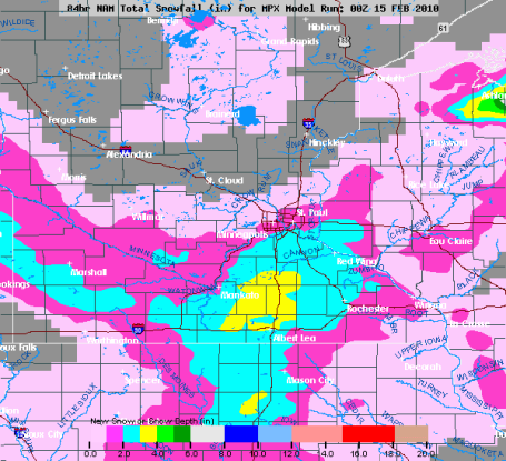
The big (snowy) Apple? The latest NAM model is hinting at 12-18" of heavy, wet snow for New York City, accompanied by high winds with a potential for near blizzard conditions from Thursday night into Saturday, moisture streaming inland from the Atlantic as a storm temporarily "cuts-off" and stalls offshore. The result may be near white-out conditions across much of New England with severe impacts to travel by air and land.


The Perfect Storm? Check out the latest storm track and chronology. The intense, moisture-laden nor'easter is forecast to stall out near New York City Friday and Saturday. That extra 48 hours of snowfall may result in some 12-18" amounts just inland, but the greater New York City area may receive a crippling snowfall from the early weekend storm. The very latest storm track/timing is here.

Anatomy of a Blizzard? Check out the "cut-off low" centered over Virginia. A counterclockwise wind flow circulating around this intense storm will pump a steady stream of moisture from the Atlantic, reaching Philadelphia, New Jersey, New York City and much of New England. Although heavy rain/ice is possible near the coast a northerly wind in the lowest few thousand feet of the atmosphere may spark heavy snow bands inland.

The Big (snowy/icy/windswept) Apple. The NAM model is hinting at 3-4" for the eastern tip of Long Island, but closer to 14-18" from Manhattan and the Bronx westward to Newark and Princeton. Expect a massive weather-mess in the New York City area and much of New England through at least Saturday as the storm temporarily stalls out, pumping a firehose of Atlantic moisture inland. I expect a number of airports across the northeast (including New York City) to postpone or cancel hundreds, possibly thousands of flights from tomorrow into Saturday.

A Reasonable March? A very lamb-like start to March is predicted for next Monday, at least across Minnesota. The CPC is predicting a warmer March for the Pacific Northwest and the Upper Midwest, including the northeastern third of Minnesota, the main storm track forecast to stay well south/east of the state for the next few weeks, a continuation of the current pattern. Thank - or blame - El Nino for this weather rut, this atmospheric holding pattern.

Paul's Conservation MN Outlook for the Twin Cities and all of Minnesota

Today: Cold start, blue sky, milder than yesterday with less wind. Winds: E/SE 3-8. High: 24

Thursday night: Partly cloudy, not as cold. Low: 11

Friday: Partly sunny, closer to "average". High: 27

Saturday: Mostly cloudy - still unusually quiet for late February. Low: 13. High: 29

Sunday: Peeks of sun, a few passing flurries. Low: 14. High: near 30

Monday: A mix of clouds and sun. High: 29

Tuesday: More clouds than sun, dripping icicles return. High: 31

Wednesday: Feels like March. Mostly gray, but relatively mild. High: 33

Tuesday, February 23, 2010

More (temporary) fun with negative numbers

"Hey Paul, cold 'nuf 'fer 'ya?" Hahahahahahahahahahahahahahahahaha!!!!

No, frankly, it's not. I prefer an ambient temperature much closer to the current surface temperature of Pluto. Preferably closer to absolute zero, where all molecular activity ceases altogether. Yes, it's a bit nippy out there right now, but it's NOT the spirit-crushing, battery-draining, hair-freezing temperatures we endured the first 9 days of January. Consider it a minor relapse, a blunt reminder that spring comes only reluctantly at this latitude. The good news: it won't stay numbing for long, in fact I think we probably bottomed out Wednesday morning - subzero north and west of the Twin Cities, negative numbers greeting most residents of central and northern Minnesota. Factor in a 10 mph breeze and it feels like -10 to -25 F out there, make sure the kids (and assorted spouses) have a few extra layers on before venturing out the door. Another character-building day on the tundra.


Another snowy dumping. The latest GFS model prints out some 6-12" snowfall amounts for the Mid Atlantic states, as much as 1-2 feet of snow may pile up over the higher elevations of interior New England and upstate New York.

February recap. The last time we saw enough snow to gripe about was Feb. 14, when a whopping 1.6" fell, .7" fell on the 15th. Since then it's been a few dribs and drabs of flurries. Yes, the snow is looking pretty crusty and dirty out there right about now.

I'm impressed (a bit dazed?) by our current snow drought. It's been 11 days since we've had a "plowable" snowfall in the metro area (1.6" back on the 14th). Almost all our 14" of snow fell during the first half of the month - it's been amazingly quiet ever since, and I still don't see a storm on the southern or western horizon looking out through the first week of March. The GFS model brings an inch or two of slush into town the first weekend of March, but right now it doesn't look like a big deal. Residents of Baltimore, D.C. and Philadelphia would probably laugh at the amount of snow we've seen so far this winter. Many Mid Atlantic cities have seen nearly TWICE as much snow as we have so far this winter, and more is on the way. A classic nor'easter will work its way up the east coast, sparking near blizzard conditions for DC, Baltimore and Philly late Thursday into Friday morning, along with another half foot or more of snow. Amazing. El Nino? Possibly, although proving cause and effect with the atmosphere is problematic. Parts of central Texas picked up 3-6" of snow Tuesday, the heaviest amounts staying SOUTH of Dallas, near Waco and Lufkin. That same storm will gain strength as it pushes east, tapping moisture from the Gulf of Mexico and the Atlantic, dropping some 1-2 FOOT amounts over interior New England. Rain will mix in for New York and Boston, but just 50-100 miles inland they may be counting snow by the foot, not the inch.


24 hour temperature trend. Note the 10 to 20 degree F. temperature drops over the Upper Midwest. No kidding!

Temperatures moderate statewide as the week goes on, a string of 30s next week as we thaw out one more time. Daytime highs should be near or above freezing almost every day next week. No more arctic swipes are in sight through mid March. This year March will definitely come in like a lamb. That means it will go out like a chipmunk, right? In like a yak, out like an aardvark. Never was good with animals....

Minnesota? Try again. How 'bout Lubbock, Texas, where 2-4" of snow fell Tuesday. Yes, I have an uncontrollable urge to ski Texas. I should get that checked out.

Paul's Conservation MN Outlook for the Twin Cities and all of Minnesota:


Today: Bright sun, numbing breeze. Winds: NW 5-15. High: 14

Wednesday night: Clear, still plenty cold. Low: 2 (subzero in the suburbs).

Thursday: Lot's of sun, not as cold. High: 22

Friday: Partly sunny, feeling a little better out there. Low: 5. High: 25

Saturday: Mix of clouds and sun, good travel conditions. Low: 9. High: 27

Sunday: Good weather to play in the snow. Intervals of sun. Low: 10. High: 28

Monday: Fading sun behind increasing clouds, closer to average. Low: 15. High: 30

Tuesday: Mostly cloudy, flurries or drizzle as we finally thaw out. Low: 19. High: 33

Monday, February 22, 2010

Tumbling Temperatures

A short & sweet (?) weather update tonight, because let's be honest here: there's precious little to talk about in the weather department. I'm OK with that, btw, because I know (from past experience) that our snow-drought will come to an end in a week or two. It can't stay this quiet much longer - at some point the other shoe (boot) will drop and once again weather will lead area newscasts. More reporters standing out in the snow and slush, telling us that it's snowing and slushing.

A blustery dusting. The chance of accumulating snow increases the farther north/east you drive across Minnesota today. An inch or so of snow is possible from Princeton to Hinckley and Duluth, maybe 3-6" for far northern Wisconsin (the result of lake effect snow).

You'll feel a new sting in the air today as temperatures tumble through the 20s into the teens, a raw northwest wind making it feel like zero later today. That's right: more wind-chill-babble clogging the TV and radio airwaves today. The mercury dips below zero over central and northern Minnesota the next couple of nights, but this will be a brief, glancing blow of arctic air. The core of the bitter air will pass off a few hundred miles to our north and east - this won't be anything like the first 12 days of January. The sun is simply too high in the southern sky, as powerful as it was the third week of October. By the end of the week daytime highs will recover well into the 20s - it looks like a string of low/mid 30s next week. Another thaw, more dripping icicles and gurgling drainspouts. It's been 2 weeks since we've seen enough snow to shovel and plow, and I STILL don't see a "plowable" snowfall looking out through the second week of March. The arrival of numbing air may set off a dusting of snow today, a few roads may get iced up, but I don't expect any widespread travel problems. Today's clipper is starved for moisture, that will limit just how many flakes fall out of that cold, slate-gray sky.

An historic January? According to NCDC much of the planet experience a warmer-than-average January. Red dots signify warmer temperatures last month, the larger the dot the greater the temperature departure from normal. The eastern two thirds of the USA and much of Europe/Asia had a colder than normal January, but that seemed to be the exception and not the rule worldwide. For all the climate information you can possibly digest click here.

Breaking climate news from the NCDC, the National Climatic Data Center in Asheville, North Carolina. We've been preoccupied by some of the bizarre weather, especially the records snows in the Baltimore/D.C. area a couple weeks back. Yes, 40" over 5 days from two separate storms is a pretty big deal. But stepping back, taking a big (global) picture it turns out that January was the 4th warmest since 1880. The world's oceans experienced the second warmest January on record, second only to 1998, the most intense El Nino year on record. Could the current El Nino be keeping the planet warmer than it would be otherwise? Absolutely. February is running 1-2 degrees F. warmer than average across most of Minnesota - the entire winter is running a few degrees above average across not only Minnesota and Wisconsin but most northern tier states of the USA, while readings are dramatically colder over the southeastern USA (and Florida). Blame (or thank) El Nino. Why not - it's an easy scapegoat. When anything goes wrong in my life I blame El Nino. It's the bane of my existence, frankly. I'd have a full head of hair (and weigh 10-15 pounds less) if it wasn't for that dang-blasted El Nino! At this rate I may have to organize a protest of some sort. Stay tuned....

  • The combined global land and ocean average surface temperature for January 2010 was 0.60°C (1.08°F) above the 20th century average of 12.0°C (53.6°F). This is the fourth warmest January on record.
  • The global land surface temperature for January 2010 was 0.83°C (1.49°F) above the 20th century average of 2.8°C (37.0°F)—the twelfth warmest January on record. Land areas in the Southern Hemisphere were the warmest on record for January. In the Northern Hemisphere, which has much more land, comparatively, land surface temperatures were 18th warmest on record.
  • The worldwide ocean surface temperature for January 2010 was the second warmest—behind 1998—on record for January, 0.52°C (0.94°F) above the 20th century average of 15.8°C (60.5°F). This can be partially attributed to the persistence of El Niño across the equatorial Pacific Ocean. According to NOAA's Climate Prediction Center (CPC), El Niño is expected to continue through the Northern Hemisphere spring 2010. (source: NCDC)

Paul's Conservation MN Outlook for the Twin Cities and all of Minnesota

Today: Mostly cloudy, gusty, turning colder - a dusting of flurries possible. Winds: NW 15-25. High: 20 (falling)

Tuesday night: Partial clearing, plenty cold. Low: near 0 (-5 outlying suburbs).

Wednesday: Blue sky, numbing breeze. High: 15

Thursday: Lingering sunshine, not as cold. Low: 1. High: 22

Friday: Partly sunny. High: 28

Saturday: Mix of sun & flakes. High: 29

Monday: Closer to average, mix of clouds and sun. High: 31

Saturday, February 20, 2010

Pothole season comes early...

Praying for a gradual thaw. The latest flood forecast has been released by NOAA. There is a better than 50/50 chance of "major flooding" from St. Paul to Hastings and Red Wing. The odds of major flooding in Fargo? 98% Hopefully our eventual spring thaw will be gradual (not accompanied by heavy rain). For the very latest details from NOAA hydrologists (river forecasters) - literally a science within a science - click here.


Good news for commuters. Bad news for snow-loving kids of all ages. The latest storm sliding off to our south will drop a "plowable" snow on much of the Midwest and Great Lakes. Models are hinting at a whopping half inch of snow Tuesday as colder air arrives - no breaking weather news anytime soon.

The last week or so has been unusually pleasant across Minnesota, temperatures running 5-10 degrees above average. Nice to be serenaded by dripping icicles and gurgling drain spouts, although all that melting snow has the unpleasant tendency to re-freeze at night, resulting in glare ice every morning. Water is one of the few elements that EXPANDS when it freezes at night, so all those little cracks in the pavement that fill up with water fill up with water by day, freeze (and expand outward) at night, literally pulverizing highways over time. Yes, we're heading into pothole season in Minnesota, the result of the freeze-thaw cycle. Like gravity (and taxes) it can't be avoided, I fear. Between the ice - and the potholes - and the wet patches throwing up a dirty spray on your windshield - driving can be hazardous - even with nothing falling from the heavens.

Saturday Highs. Click on the graphic to bring it full-screen. Highs were in the low to mid 30s from St. Cloud to the Twin Cities - cooler just south and west (where there is more snow on the ground).

That sloppy caveat aside, there has been precious little to complain about in the weather department in recent days. Saturday's high in the Twin Cities was a relatively balmy 35 (5 degrees above average, 9 degrees warmer than last year on this date). That makes 4 days above freezing since last Tuesday, February temperatures now +1 F. in the metro area - in spite of 13" of snow on the ground. While parts of America wrestle with snow and ice we experienced an odd "Air Pollution Advisory". We've seen at least 5-6 days in the last few weeks with unusually light winds and an "inversion" overhead, temperatures warming with altitude, trapping man-made pollutants near the ground. Mid-winter smog? I know. It's a little strange. Unusual, but not unprecedented. As I wrote last week, rain/ice is becoming more frequent during January and February - according to Professor Mark Seeley at the U. of MN the frequency of ice in Jan/Feb has quadrupled since 2003. We also seem to be seeing more air pollution events during the winter. A smoking gun? Not sure we can chalk this up to climate change (or even El Nino for that matter).

Prediction: frustrated Minnesota snow-lovers. Close but no-go. The models are printing out an inch of liquid water from central Missouri into western Illinois (which may translate into 10-12" of snow). Chicago: potential for 6-8" or more. The forecast is valid from 7 am Sunday through 7 am Monday.

Blame (or thank) El Nino. Unusually warm water in the equatorial Pacific Ocean may be causing the storm track to become temporarily "locked", bringing more heavy snow from the central Plains to Chicago and Detroit. Click here to see the latest NOAA watches and warnings.

Back to reality. Here are Wednesday's predicted highs: close to 20 in the Twin Cities, holding in the teens across much of central and northern Minnesota. With a sun angle as high in the sky as it was during the third week of October it's getting increasingly difficult for temperatures to fall below zero. Difficult but not impossible. I'll be shocked if we don't experience at least a couple more subzero lows before spring arrives in earnest. Where the heck is Earnest, anyway?

I still don't see any real storms looking out 10-14 days. The models consistently keep any real "weather" passing off a couple hundred miles to our south. Another major snow/ice/rain storm may be shaping up for the east coast by the first week of March. Minnesota temperatures run 5-10 degrees below average this week, cooler than average weather probably hanging on through the first week of March. I do expect a warming trend the second week of March, more 30s likely. No dramatic warm-ups (good news for people living in flood-prone areas of the state). At some point that active storm track will probably shift northward - expect a stormier, more active weather pattern the middle and end of March. No, we haven't seen the last of the snow. Statistically we should pick up at least another 10-20" before the first daffodils of spring appear. Count on it.

Paul's Conservation Minnesota Outlook for the Twin Cities and all of Minnesota:

Today: Intervals of sun, still milder than average. Winds: N 5-10. High: 32

Tonight: Patchy clouds. Low: 18

Monday: Mostly cloudy, feeling a cooler breeze. High: 29

Tuesday: Potential for a little light snow/flurries. Coating - 1/2" possible. High: 21

Wednesday: Cold sun, feels like February again. High: 19

Thursday: Blue sky - brisk. High: 18 (after waking up to 3 F).

Friday: Mostly cloudy, temperatures trending upward. High: 21

Saturday: Mostly gray, closer to average again. High: 27

Friday, February 19, 2010

Snow: the good, bad & ugly

While young men and women from around the world celebrate the fun side of snow and ice in Vancouver for the Winter Olympics, we're reminded of the high cost of snow and ice (where it's not nearly as wanted and appreciated). From "Planalytics", a weather-intelligence company:

* Last week's paralyzing snow from Dallas (12.5") to D.C. (40" over 5 days) left millions of Americans unable to get to work, no shopping, no retail, no restaurant visits, etc. A rough, back-of-the-envelope calculation suggests that the subsequent loss of sales and productivity may have reached as high as $36-38 billion from last week's parade of snow and ice storms alone!

* It costs the federal government an estimated $100 million for every DAY it's shut down. Many federal organizations have been closed for nearly 2 weeks now.

* New York City estimates that it costs $1 million/inch to remove snow from the city's streets.

Vancouver, British Columbia. It's been in the 50s downtown, Olympic officials scrambling to keep snow on the slopes. The calendar says mid February, but as far as the atmosphere is concerned it looks and feels more like late March in the Vancouver area right now - probably the result of El Nino warming of Pacific Ocean water.

* El Nino is probably responsible for record-warmth from Vancouver across much of Canada, experiencing one of the 3 or 4 warmest winters on record. Some of this warmth is spilling over into the northern tier states, including Minnesota and Wisconsin - a few degrees above average for the winter, to date. The strong warming of Pacific Ocean water is thought to be at least partially responsible for an extra-energized southern branch of the jet stream, guiding big, wet (at times violent) storms across the Pacific into California, then eastward into Dixie and the eastern seaboard, each subsequent storm pulling unusually cool air south in its wake.

* 31 degree high in the cities Friday, after 3 days in a row above freezing Tuesday, Wednesday and Thursday. February temperatures are running 1.2 degrees above average so far.

* 40.6" of snow so far for the Twin Cities, very close to where we should be as of Feb. 20. But closer to 50-60" has fallen over parts of southern and western Minnesota, where as much as 5-10" of liquid water is tied up in the snow pack.

Probability of Major Flooding. NOAA is predicting a 96% chance of "major flooding" in Fargo, a 60% risk for downtown St. Paul. Red dots show towns with a greater than 80% risk of major flooding. Yellow dots indicate a 40-60% risk of major flooding, including St. Paul, Hastings and Red Wing. To explore NOAA's flood site for yourself click here.

* NOAA hydrologists (river forecasters) now say there's a 90% chance of flooding on the Mississippi in St. Paul, a 60% risk of "major flooding" in late March and April. It will all depend on how quickly spring arrives. Any sudden thaw, accompanied by heavy rain, will accelerate snow melt and flush snowmelt into area tributaries, increasing the potential for serious flooding. Last year's Red River flooding is still fresh in a lot of minds (60 days above flood stage in the Fargo area). There have never been two epic flood seasons, back to back. If it happens again in 2010 it would be truly historic.

* Friday night on TPTs "Almanac" program the question came up, "why do most Minnesotans believe it's been such a tough winter (when it really hasn't been). My answer: "We've become a state of big weather wussies." (sp?) We were spoiled for much of 2000-2009 with a handful of historically mild, snow-free winters. Some of us thought, "hey, great! This is the new norm." Not so fast. The atmosphere has an uncanny ability to "even things out". A few warm winters are often followed by a few unusually cold winter, but in the end it all pretty much evens out.

* Historically we have another 10-20" of snow left to go, but the odds of sustained, subzero weather are dropping off now with every passing day. The GFS model is hinting at a couple of subzero nights around the first weekend of March, but the odds of a few WEEKS of sustained, bitterly cold weather (like what we endured the first 12 days of January) are slim to 'nil.

Famous last words.


* Water vapor in the atmosphere has increased by about 5% in recent decades. A warmer airmass can hold more water. Basic physics. So does this mean the weather dice is loaded to favor more frequent, intense rainfall (and snowstorms?) Click here for an intriguing story in nationalgeographic.com.

* Do vacations boost happiness? Man, I hope so! Just THINKING about future vacations is enough to pull me out of a dark, slushy funk. The story in livescience.com (and Yahoo) is here. Thanks to Tricia Frostad for passing this along!

White-knuckle Monday AM Commute? Long-range guidance is hinting at an inch, maybe 2" across the southern third of Minnesota Monday, the brunt of the snow passing off south of town.

Paul's Conservation MN Outlook for the Twin Cities and all of Minnesota

Today: Intervals of sun, seasonably cool. Winds: NW 5-10. High: 29

Saturday night: Partly cloudy, chilly. Low: 14

Sunday: Mostly cloudy, few flakes possible late. High: 27

Monday: Period of light snow, maybe an inch or two. High: 25

Tuesday: Flurries giving way to some PM sun. High: 23

Wednesday: Noticeably colder with blue sky. High: 21 (single digit lows)

Thursday: Plenty of sun - brisk. High: 22

Friday: Clouds increase, a bit closer to "average". High: 26

Wednesday, February 17, 2010

Loading the Dice?

Weather Factoids

Forecasting a snowfall: the bigger the better. Wait a minute. Snow + TV = Ratings? Amazing! For a big dose of what you probably already knew click here.

Sportsmen key in global warming debate. Do the recent snowstorms in Dallas and D.C. refute climate change, or are these extreme events more evidence? Hunters and fishermen are already noticing changes, literally out in the field. For more click here to read a story from the Sioux Falls Argus Leader.


Minnesota's evolving winters. According to Professor Mark Seeley at the U. of Minnesota the frequency of ice events in January and February have QUADRUPLED since 2003. Coincidence? Maybe. For more details click here.


An Upside Down Winter. Classic El Nino winters are on the right, showing a trend toward cooler south and warmer north. But this winter has been an extreme case, with temperatures as much as 10 degrees warmer than average across Canada, some 8-10 degrees colder for the southeastern USA. This takes "odd weather" to an entirely new level.

El Nino is in full swing, loading the weather-dice to favor more frequent, moist and intense storms across the southern and eastern USA. Freakish one foot plus snowfalls for Dallas, 80+" of snow in the suburbs of Baltimore, so much that authorities have run out of places to push the slush. Although every El Nino event is unique, the vast majority favor milder, drier weather over the northern tier states of the USA and Canada. Vancouver's blooming cherry blossoms and slushy ski runs are just the tip of the iceberg. Canada is enjoying /enduring the 3rd warmest winter on record as Pacific steering winds push well inland, boosting temperatures as much as 10 degrees F. warmer than average since early January. Meanwhile, numbing air from the Arctic Circle has been draining south across Hudson Bay and Quebec, circulating all the way into the Great Lakes and New England. In recent weeks these prevailing winds, the core of the jet stream, the main superhighway for storms, has been running from California to Oklahoma, Memphis and D.C., taking a detour well south of Minnesota. At some point the storm track will shift north again, but I don't see that happening through at least the first week of March. Our winter weather siesta will continue another 10-14 days. Good news for travelers. Bad news for snow lovers (although it won't warm up enough to melt significant snow anytime soon).

An Historic Snowfall. 40-45" in a 5 day period? This high-resolution satellite image was taken days after "Snowmageddon", showing the bright, intense white of fresh snow across the Mid Atlantic States (vs. the scalloped white of low clouds off the east coast).

The weak bubble of high pressure responsible for a week's worth of sunshine and temperatures a good 5 degrees above average (two days above freezing with dripping icicles!) will hang on through Friday. Once again today we may eclipse freezing under a partly-blue sky, a light northwest breeze, the sun as high in the sky as it was back on October 23. If you wander outside into direct sunlight you can really FEEL the difference now. We're picking up 1-2 minutes of additional daylight every day, average temperatures are on the rise, and with each passing day the risk of subzero weather drops off rapidly. I seriously doubt we'll see another subzero daytime high, although a couple more subzero lows are likely before warm fronts have the strength to reach this latitude.

Loading The Dice? Climatologists tell us that there is an estimated 5% more water vapor in the air today than there was a generation ago. A warmer atmosphere can hold more water. There is a growing body of evidence that this spike in water vapor is sparking more extreme precipitation events: flash floods, river flooding, and potentially increasing the odds of major snowfalls. Proving cause and effect with the atmosphere is never straightforward, and many factors may be involved, including a moderate to strong El Nino causing the storm track to temporarily "lock" over the southern and eastern USA. A complicated puzzle? You bet.

Paul's Conservation MN Outlook for the Twin Cities

Today: Plenty of sun, still milder than average. Winds: NW 5-10. High: 32

Tonight: Partly cloudy, still quiet. Low: 15

Friday: Less sun, more clouds, dry. High: 29

Saturday: Mostly cloudy, a few flurries possible. High: 27

Sunday: Overcast, more flurries, nothing more than a dusting. High: 26

Monday: A period of very light snow/flurries, maybe a coating. High: near 30

Tuesday: Flurries giving way to partial clearing, gusty winds. High: 26

Wednesday: Mostly sunny and chilly. High: 22

Tuesday, February 16, 2010

The United (quirky) States of America

Paul's Conservation Minnesota Outlook for the Twin Cities

Today: Partly sunny, milder than average. Winds: NW 8-13. High: 33

Tonight: Partly cloudy. Low: 11

Thursday: More clouds than sun, slightly cooler. High: 29

Friday: Mix of clouds and sunshine, temperatures close to average. High: 28

Saturday: Mostly cloudy, still storm-free. High: 26

Sunday: More clouds, a few flurries (dusting possible). High: 28

Monday: Leftover clouds, flurries, no more than a coating. High: 31

Tuesday: Increasingly sunny, turning noticeably colder. High: 19


Welcome thaw. The mercury hit 34 F. on Tuesday, 5 degrees above average (in spite of 17" of snow on the ground). It was the first time in 11 days the temperature has gone above freezing in the Twin Cities.

* So far the metro area has experienced HALF as many subzero nights this winter compared to last (15 since December, 2009, compared to 29 last winter at this time).

* Feeling a little perkier? No, me neither. But if you do have a little kick in your step you can thank a higher sun angle (as high in the sky as it was on October 23). We've picked up 103 minutes of daylight since Dec. 21. Can spring be far behind? You betcha!

What a strange winter. Ski tournaments in Vermont have been canceled due to a quirky lack of snow. Meanwhile officials don't know what to do with the 40-50" snow still on the ground in the Philadelphia - Baltimore - Washington D.C. area, experiencing a truly historic winter, the most snow in 100-150 years of record-keeping. Last week Dallas was buried under 12.5" of snow, smashing a handful of records, by far the most snow that city has ever seen in modern-day records. Last Friday there was a moment where snow was reported in all 50 states (a coating on the Florida panhandle, snow on the summit of Hawaii's volcanoes).

More slush than ice. Cypress Mountain, outside Vancouver, where the snowboard festivities are taking place for the Winter Olympics. Recent rains and daytime highs in the 40s have created very challenging conditions for officials trying to keep ice in competition-ready condition.

Which makes the snow situation (or lack thereof) for the 2010 Winter Olympics in Vancouver that much more of a head-scratcher. It's been a remarkably mild winter for British Columbia, the best theoretical (guess) is that a strong El Nino is responsible for a persistent Pacific breeze, blowing unusually mild air into the Vancouver area. It has been so mild that CHERRY BLOSSOMS are blooming in downtown Vancouver right now! There was no snow in the city during January - NONE! As early as Christmas Olympic officials brought in snow-making machines. In recent weeks the "green" Olympics have been forced to truck in many, many tons of snow from surrounding mountains. It was 50 yesterday (in the city), temperatures well into the 40s on the slopes. Cyprus Mountain, home of the snowboarding competitions, has been hardest hit by the warmth and rain (and fog!) It's been a full-time job for officials to try to keep the ice in competition-form, and the forecast for the rest of the week calls for more 40s, but the rain may be winding down, which would be a blessing. Don't be surprised if more Olympic events are postponed, even canceled, due to the unseasonably mild, Marchlike weather. For a great summary of the unusually mild weather click here.

A long list of records. Here are 24 hours worth of weather records for the USA. Note the snow (and rainfall) records for southeastern Minnesota (from Monday's storm). More snowfall records for the Ohio Valley, and high temperature records for the Pacific Northwest (and the Vancouver, British Columbia area). Click here to go to Ham Weather, a division of WeatherNation, where you can see the individual city record details.

Yesterday felt great, highs reaching the mid 30s, a faint whiff of March in the air. Predicting highs with significant snow on the ground is always tricky. The snow acts as a refrigerant, cooling the air from below. The wind direction seems to make all the difference. And here I thought a high of 30 was going out on a limb. Boundary layer temperatures (a few hundred feet above the ground, the level at which there is no frictional component to the wind flowing overhead) are nearly as mild later today as they were yesterday, so we may nudge freezing once again. Temperatures cool off (slightly) as we slide into the weekend, a dusting/coating of flurries possible by Sunday or Monday of next week (a "nuisance snow" at most). Much colder weather returns next week, with 2-3 days in the teens (at least the sun should be out). Long-range guidance is hinting at a potentially major snowstorm for Des Moines and Chicago by the end of next week. That's still way out on the horizon, laughably early to talk timing and potential amounts for Minnesota, but it's conceivable we could pick up a couple inches of snow on the northern fringe of the storm by next Thursday. Stay tuned....

Close encounter of the snowy kind next Thursday, Feb. 25? Day 10 of the GFS model shows a significant storm pushing north across the Mississippi River Valley, brushing central and southern Minnesota with a couple inches of snow. This forecast WILL change over time, as new data arrives (4 new model runs/daily). Just know that the pattern may become considerably more active by the latter half of next week.

Blame it on El Nino? The barrage of winter storms steam-rolling across much of the southern and eastern US may be a symptom of a moderate El Nino. One possible silver lining? El Nino winters tend to be followed by milder tornado seasons across the USA. Time will tell if that's the case in 2010.

Sunday, February 14, 2010

Midwinter Reality Check

* 1-3" snow Monday, more south, less north of the cities. Snow should gradually taper off by afternoon with a cold north wind.

* Storm-free weather should be the rule from Tuesday through the weekend, temperatures within a few degrees of average for mid February.

* The GFS is hinting at 30-34 degree highs from Feb. 24-28, maybe a few inches of slushy, wet snow by the last 2 days of the month.

* Complete 7-Day Forecast: scroll down to the bottom of the post.

It's good to be home, after a week of "studying tropical weather patterns"in the Caribbean. I keep telling anyone who will listen that the key to surviving a Minnesota winter is a few well-timed get-aways. I figure I should practice what I preach. For the record I spent a week on Royal Caribbean's "Independence of the Seas", an amazing ship. I went on as a "guest", came back off 7 days later as "cargo", determined to get rid of the extra 5-7 pounds I packed on. Yes, at the rate I was eating I was afraid I might show up on Doppler Radar - got out just in time. Quite a shock to the system, going from 90 in San Juan to 20 at MSP, but I don't think I'm 'gonna get much sympathy today.

Predicted Snowfall for the next 48 hours, some 3" amounts south of the MSP metro

Barely "Plowable". The latest NAM model shows some 1/2 to 1" snowfall amounts for the north metro, but closer to 2-3" just south of the MN River. Burnsville, Lakeville and Woodbury stand a much better chance of 2-3" of powder than Andover and Elk River today. Most of the accumulating snow should be winding down to flurries by afternoon.

Allow extra time to get to work or school Monday morning: we should easily pick up a couple of inches (1" or so north metro, but 2-3" of powder may grease up highways across the south metro). A stiff north wind will blow, whipping up some minor blowing & drifting, especially outside the metro area, with lower visibility near Burnsville and Lakeville - travel conditions getting tougher the farther south you drive down I-35 or Highway 61. This is about as exciting as it gets all week - most of the big, sloppy storms will detour well south of Minnesota this week, just brushing us with a few flurries late Friday and Saturday, little more than a dusting late-week. No mega-storms are brewing looking out through the end of February, but the GFS model has filled me with hope: daytime highs may top 32 from roughly Feb. 24-28 as the upper level steering winds become more "zonal", more west to east. The latest run brings in a few inches of heavy, wet, slushy snow the last weekend of February, right around Feb. 27-28. We'll see. Let's just say that the Groundhog had the right idea, spring is NOT right around the corner.

Weather Nuggets

* 38.3" of snow on the ground at MSP as of Sunday, Feb. 14: that's about .3" more than usual as of Feb. 15, and 8" more than we had last year at this time. But it's less than HALF as much snow as Washington D.C. and Baltimore have picked up so far this winter.

* According to the DNR there's a cool 18-24" of snow on the ground roughly south/west of I-94. According to NOAA estimates there may be as much as 4-6"+ liquid water tied up in that snow cover. If we see a gradual thaw later in March (and no heavy rain events) then we may dodge the flood bullet later in the spring. Although the odds of a flood similar to the one that haunted the Red River Valley for 60+ days in 2009 is small, I'm still worried about the potential for significant flooding along the Minnesota and the Red River 30-60 days from now. If we "limp into spring" we'll probably be ok. But if we see instant-50s, coupled with a few heavy, consecutive rainstorms, then the risk of serious flooding rises by an order of magnitude.

* According to NOAA - in the last week snow has been reported in EVERY one America's 50 states! The last time that happened may have been the harsh winter of 1976-77, when flurries were spotted as far south as Miami Beach!

* According to a weather-intelligence company called Planalytics, it's estimated that a third to a half of all residents of North America experienced significant snow in the last week.

* FAA reports 20,000+ flights impacted by heavy snow last week, impacting roughly 2 million travelers.


Photo courtesy of the Dallas Morning News.

* Dallas experienced 11" of snow on Feb. 11, the most for any day in the city's history. A total of 12.5" of snow fell, much to the chagrin of local TV meteorologists, who had predicted 1-3" from the storm. This is every meteorologist's worst nightmare, right up there with missing a deadly tornado. For a complete recap on what happened, and why the forecasts were off by so much, click here.

* An estimated 1,200 daily snowfall records were set, nationwide, just last week.

* The DC/Baltimore/Philadelphia area was hit by two 20" snowfalls in less than a week, many cities are reporting 30-45" ON THE GROUND as of this morning - incredible for cities that tend to panic when a measly inch of snow falls!

City Season To Date (Inches) Normal Season (October-March)

Baltimore* 79.9” 22”

Philadelphia* 72.1” 23”

Pittsburgh 57.8” 43”

Washington, DC* 55.9” 22”

Chicago 45.3” 37”

Dallas 15.7” 3”

*All time record for most snowfall in one winter season.

· 1,200 daily snowfall records were set over the past week. Some notables:

o Chicago set a daily record when 12.6 inches fell on February 9 – shattering the old record set in 1885.

o Detroit set a daily record when 6.5 inches fell on February 9 – shattering the old record set in 1886.

o Pittsburgh received 5.2 inches of snow on February 10 – setting a new record and making this the 6th snowiest month ever in city history.

o Baltimore, Washington, DC and Philadelphia each set numerous daily snowfall records throughout the past week.

Including last week’s snowfall and heavy rain events, the retail year is off to its snowiest and wettest start in over 12 years. (source: Planalytics).

Paul's Outlook for the Twin Cities

Today: Light snow, tapering to flurries by late afternoon. Totals of 1-3" (1-2" north metro, closer to 2-3" for some southern suburbs). Winds: N/NW 15-25. High: 22, falling into the teens PM hours.

Monday night: Flurries taper, slippery roads. Low: 8

Tuesday: Intervals of sun, better travel day. High: 21

Wednesday: Partly sunny, storm-free. High: 23

Thursday: Clouds increase, close to "average" for this time of year. Significant storms pass south of MN. High: 25

Friday: Intervals of sun, gusty winds. High: 23

Saturday: Clouds, flurries, a dusting possible. High: 21

Sunday: Blue sky returns, nothing "arctic" in sight. High: 24

Presidents' Day Gold Medal Forecast

I feel like a bump on a log lately, sitting on the couch for countless hours while I watch some of the most amazing athletes in the 2010 Olympic Games do incredible things. I think the thing that impresses me the most about the games is that there seems to be more Olympic Records and World Records set every year! how do they do it? Take a look at the athletes. They get bigger, faster and stronger every year. The gear the athletes use and wear gets better every year and the facilities/course conditions for various sports tends to stay at optimal levels for a longer periods of time. The variability between each heat and racer is minimized, so that everyone has a chance to perform under 'perfect' conditions. Just think about how much the Olympics Games have changed in years past, no wonder why, eh!


From the touching stories of the athletes to the medal ceremonies to the endless amounts of media coverage, you really can't help but enjoy the games for what they stand for. I'm finding myself even enjoying the 'not so typical' events. The events that I am really looking forward too, though, are the hockey games, both men and women. The men's hockey should be a real treat to watch because most of the players are in the NHL. It'll be like watching the All-Star Game each time the puck drops!

OK - OK - enough about the games, how about this weather. There's nothing too exciting about it really, but that light snow should be just enough to make the morning commute and afternoon commute a little hairy. The morning commute will likely out weight the two, so plan accordingly. You may, however, notice a few less cars on the road today due to it being Presidents' Day. That may help the situation out a little. In the meantime, here's how much storm total snowfall to expect from yesterday through today:


Gusty winds will keep the blowing/drifting snow and wind chill factors in play today, but tomorrow is going to be much quieter. In fact, It'll feel quite a bit warmer tomorrow and through the rest of the week as winds subside and temperatures crawl back to near normal levels. There may be a little light flurry activity by midweek, but it doesn't look like an issue at this point. You'll be able to focus on the tasks at hand this week with little distraction from the local weather. I predict that you'll also hear less and less about the recent "Snowpocalypse" from meteorologists as the dust continues to settle and we all begin taking our medication again. Yes, it's true that meteorologists can get a little carried away when talking about the weather sometimes, but like a kid in a candy shop, it's hard to resist the temptation when storms get loaded and bloated with all the right stuff. I'm still searching the extended models for the next big warm up or Arctic outbreak... still nothing yet. Have a good Monday.


Todd's Outlook for the Twin Cities


Monday (Presidents' Day): Lingering light snow early, still breezy. High: 25

Monday Night: Becoming partly cloudy and not as breezy. Low: 12

Tuesday: Mostly sunny, feeling warmer. High: 27

Wednesday: Mix of clouds and sun, a flurry or two possible. High: 28

Thursday: Partly cloudy. High: 29

Friday: Partly cloudy. High: 25

Saturday: partly cloudy. A couple of flakes possible. High: 25

Sunday: Mostly sunny and quiet. High: 24

Saturday, February 13, 2010

Retrograding Low Brings Light Snow

I love winter days like yesterday where everything is candy-coated in a brilliant white fluff. It's like a scene out of a snow globe after all the snow has settled. The phenomenon is known as "Rime Ice" or "Hoarfrost"

*This explanation of hoarfrost is from www.gi.alaska.edu* "If when air is cooled down it contains enough water to cause the dew point to be above freezing, then dew forms. But if the air is sufficiently dry that the dew point is below 0°C (32°F), then hoarfrost forms. Hoarfrost consists of crystalline structures that grow from water vapor evaporated from liquid droplets suspended in air. Once hoar-frost crystals form, they can remain as long as conditions for their existence are favorable."

Wasn't it a beautiful site yesterday?


Today will be a fairly quiet start to the day, but it'll get somewhat interesting by the end of the day. At our latitude, weather normally comes in from the west, but every once in a while we'll get storms that come in from the east. That'll be the case later today as a storm backs in from the central Great Lakes Region or "Retrogrades" (moves from east to west). Take a look at the animation here - this system weak disturbance will linger through Monday and will have enough moisture to give us some light accumulations Sunday night in to early Monday. The one thing you will notice this afternoon is the increase winds. It will be quite a bit more breezy today and tomorrow compared to the last few days. There will, in fact, be a whiff of wind chill out there the next couple of days, which may take your breath away at times. I am still comparing every 'chilly' day to the cold snap of early January and, good news, we will be no where near that nor will be no where near that the rest of the winter season. Sure, it maybe cold from time to time, but we are pulling out of the deep freeze slowly but surely. By the way, spring is only 34 days away! Have a good Sunday.


Todd's Outlook for the Twin Cities


Sunday: Cupid sightings likely. Some sun early with increasing clouds and light snow showers developing late. Breezy. High 20

Sunday Night: Mostly cloudy with light snow showers and light accumulations by morning. Low: 11

Monday (Presidents' Day): Lingering light snow early, still breezy. High: 22

Tuesday: Mostly sunny, feeling warmer. High: 24

Wednesday: Partly cloudy with scattered flurries and light snow showers developing late. High: 26

Thursday: More sunshine. High: 25

Friday: Mostly sunny. High: 26

Saturday: partly cloudy. A couple of flakes possible. High: 25

Friday, February 12, 2010

Thinking Warm Thoughts

Happy Saturday everyone! I hope you were able to sleep in a bit today and are enjoying your day off, though, if you are a weekend warrior (like myself) I feel you! You may be a bit more tired today after watching the countless number of some of the most amazing athletes from around the world march into BC Place Stadium in Vancouver British Columbia. Unfortunately, the games are shadowed by shocking news of a 21 year old Georgian Luger who crashed a few hours before the opening ceremony. Interestingly, the Vancouver Luge/skeleton/Bob Sled race track is dubbed as the fastest course in the world, where speeds can climb to as high as the low to mid 90's! I have to admit, I went into the evening with a heavy heart, but to see the Georgians march into the stadium after such a tragic event and to have the 'world' give them a standing ovation was uplifting.


Nodar Kumaritashvili 1989 - 2010


Thinking Warm Thoughts

Have you been too cold lately? These numbers might help out a little. Don't be alarmed if you have a quick flashback to summer-like feelings or a warm tingling sensation when I read some of these numbers.

Normal High Temperatures:
Today - February 13th ..... 28 degrees
End of the Month - February 28th ..... 34 degrees
First day of Spring, March 20th, only 35 days away! ..... 42 degrees
End of April ..... 63 degrees
End of May ..... 75 degrees
End of June ..... 82 degrees

Did that help any? I like a good snow storm, but I am an even bigger fan of a rain/thunderstorm... I think I can smell the fresh rain now - SIGH

Here's a picture that I took one summer evening a few years back
I was pretty lucky to get this picture:


Back to reality
As we step back into our bodies and take a look outside, you'll see lots of ice and snow and when you put your nose into the wind, you'll have no doubt that it's still winter. However, at least the sun is feeling decent at this stage of the game.

A clipper will roll through just southwest of us today, keeping the accumulating snow well away from us. We may get a few flurries out of this one, but our next best chance of snow won't swing in until late Sunday. Even then, it appears our snow chances are limited.

Interested in Canadian Weather? Vancouver Weather?
Canada has a government weather office, see here


Todd's Outlook for the Twin Cities


Saturday: Some morning fog, then a mix of clouds and sun with a little light snow possible. Accumulations likely in far southwest MN. High 24

Saturday night: Partly cloudy and chilly. Low: 7

Sunday: Cupid sightings likely. Increasing clouds with flurries and light snow showers developing late. High 22

Monday (Presidents' Day): Mix of clouds and sun with some light snow early. High: 23

Tuesday: Mostly sunny, feeling warmer. High: 23

Wednesday: Looking bright, with increasing clouds late. High: 24

Thursday: Partly sunny with scattered light snow showers. High: 25

Friday: Mostly cloudy and a few flakes. High: 27

Thursday, February 11, 2010

Clipper from Olympians

Today is the day that I've been waiting for since the last Winter Olympics (Torino Italy) back in 2006. I grew up a hockey player and living in Minnesota all my life, I've come to love a number of other winter sports, so these next 15 days of sporting events is going to be a treat. Think about it... how many times can you see the some of the best athletes from around the globe compete for their country. It truly is an uplifting event that can take your mind off of the mundane, day to day, tasks that one goes through. Step back for a moment - enjoy the camaraderie , competition and the Canadian hospitality. Vancouver is a beautiful place with some of most interesting weather on Earth. Note, Whistler had a record 220" of snow in the month of November and should remain in the 'snow' during the games, but Vancouver just went through the warmest January on record with an average temperature of 44.9 degrees. How strange is that? For the first time in Olympic history, you will witness an opening and closing ceremony indoors because of the fear of rain. Daytime high temperatures will hover in the upper 40's to low 50's during the Olympic games with rain showers - don't be surprised when you here the commentators talking about rare rain showers during the Olympic events... Vancouver is a harbor city next to an ocean, so the climate is mild even in winter. In fact, Vancouver's average February temperature of 4.8 degrees Celsius and is the warmest city to ever host a Winter Olympics. By the way, 4.8 degrees Celsius is around 40 degrees Fahrenheit.


A Few Numbers/Conversions to Remember During the Olympics:

Now you can convert from Centigrade to Fahrenheit with these quick references...
10 degrees Celsius = 50 degrees Fahrenheit
0 degrees Celsius = 32 degrees Fahrenheit
-10 degrees Celsius = 14 degrees Fahrenheit

Also, remember that every 1 degree Celsius = 1.8 degrees Fahrenheit.


Minnesota Twins and Canada Native, Justin Morneau, Carried Olympic Torch Yesterday @ 3:45 CST
You can watch the LIVE Olympic Torch Relay coverage here

Interestingly, once the Olympic Torch reaches Vancouver, British Columbia, it will have traveled nearly 28,000 miles and have become the longest traveled torch relay in a single country history.


In Our Neck of the Woods
Flurries and light snow showers will be possible the next couple of days, but it appears the heaviest of the snow from the next (Canadian) Alberta Clipper will be in southwestern Minnesota:


Temperatures will fall slightly behind this next clipper system, but just a few degrees. Our high temperatures over the next 5 to 7 days will hover in the mid 20's, slightly below average. I still don't see any big warm ups or Arctic outbreaks in the near future. I do, however, see the sunshine in the extended forecast, which is much stronger now than it was just a few weeks ago. Go ahead, step outside for a few second when the sun is shining brightly... I guarantee you'll notice a dramatic difference in the intensity of the sun and I bet those few seconds in the sun will last, perhaps, for a few minutes. You may even get a hint of spring fever (I know I did).


Todd's Outlook for the Twin Cities


Friday: Mostly cloudy with a few flurries and scattered light snow showers. No accumulation expected. High 24

Friday Night: Mostly cloudy. Perhaps a flurry or two. Low: 8

Saturday: Mostly cloudy. A little light snow, accumulations likely in southwest MN. High 24

Sunday: Cupid sightings possible. Lingering clouds and flurries? High 21

Monday (Presidents' Day): Mix of clouds and sun with a flake or two. High: 22

Tuesday: Partly cloudy, slightly warmer. High: 23

Wednesday: Looking bright, slightly below normal temps. High: 25

Thursday: Mostly sunny. High 26

Wednesday, February 10, 2010

Snowiest Season on Record Out East

Just for a moment, imagine yourself having to shovel and scoot around town after just going through two major winter storms with as much as 4 feet of fresh snow just under a weeks time. Also imagine the second storm blowing the new snow around at 50mph to 60mph into 10 foot snow drifts! Wouldn't that be something? I have to admit, after watching live coverage of the events unfolding out east yesterday, I was a little jealous to see such an extreme weather event. At times, blizzard conditions dropped visibilities to just a few feet for places around the Megalopolis of Baltimore, Washington D.C., New York and Philadelphia. Speaking of which, those locations just set the all-time snowiest seasons on record after this latest storm.


Records Fall This Winter Season
Take a gander at some of these impressive numbers. Note that D.C. and Baltimore have had a snowier winter than St. Cloud; Duluth; Buffalo, NY and Anchorage, AK so far this season.

Baltimore Washington International Airport as of yesterday afternoon had seasonal snow total a little over 72" beating the old record of 62.5" set in 1995-96. Records go back to 1893.

Washington Dulles International Airport as of Tuesday had a seasonal snow total of 63.5" beating the old record of 61.9" set in 1995-96.

Washington Reagan National Airport as of yesterday afternoon topped the snowiest season on record of 54.4" which was previously set in 1898-99.

Philadelphia International Airport as of yesterday evening, recorded 14" of new snow putting their seasonal snow total at 70.3" and above the snowiest season on record of 65.5" previously set in 1995-96


Proof in Pictures


Storm on Satellite


Closer to Home

We remain quiet through the day today, but clouds will be increasing this afternoon in advance of our next clipper system. Waking up tomorrow there may be a light coating of fluff on the ground, but it'll be pretty minor. Flurries and light snow chances will continue Friday and early Saturday before we clear out on Valentine's Day Sunday. The image below shows the potential snowfall through Saturday.


Looking ahead, temperatures will hover in the mid 20's for daytime highs next week. I don't see any major cold snaps or dramatic heat waves in the extended forecast. I'll keep peering into the crystal ball... until then, have a good Thursday.


Todd's Outlook for the Twin Cities


Thursday: Chilly start. Increasing clouds, a few flurries possible late. High: 19

Thursday Night: Mostly cloudy with a little light snow and not as cold. Low: 10

Friday: Mostly cloudy with light snow showers. High 25

Saturday: Mostly cloudy, a little light snow. High 25

Sunday: Cupid sightings possible, more sunshine. High 23

Monday (Presidents' Day): Threat of a mostly blue sky. High: 24

Tuesday: Partly cloudy, slightly warmer. High: 24

Wednesday: Looking bright, slightly below normal temps. High: 25