* 1-3" snow Monday, more south, less north of the cities. Snow should gradually taper off by afternoon with a cold north wind.
* Storm-free weather should be the rule from Tuesday through the weekend, temperatures within a few degrees of average for mid February.
* The GFS is hinting at 30-34 degree highs from Feb. 24-28, maybe a few inches of slushy, wet snow by the last 2 days of the month.
* Complete 7-Day Forecast: scroll down to the bottom of the post.
It's good to be home, after a week of "studying tropical weather patterns"in the Caribbean. I keep telling anyone who will listen that the key to surviving a Minnesota winter is a few well-timed get-aways. I figure I should practice what I preach. For the record I spent a week on Royal Caribbean's "Independence of the Seas", an amazing ship. I went on as a "guest", came back off 7 days later as "cargo", determined to get rid of the extra 5-7 pounds I packed on. Yes, at the rate I was eating I was afraid I might show up on Doppler Radar - got out just in time. Quite a shock to the system, going from 90 in San Juan to 20 at MSP, but I don't think I'm 'gonna get much sympathy today.
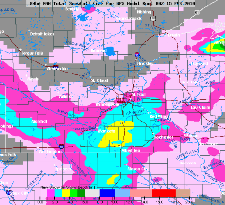
Barely "Plowable". The latest NAM model shows some 1/2 to 1" snowfall amounts for the north metro, but closer to 2-3" just south of the MN River. Burnsville, Lakeville and Woodbury stand a much better chance of 2-3" of powder than Andover and Elk River today. Most of the accumulating snow should be winding down to flurries by afternoon.
Allow extra time to get to work or school Monday morning: we should easily pick up a couple of inches (1" or so north metro, but 2-3" of powder may grease up highways across the south metro). A stiff north wind will blow, whipping up some minor blowing & drifting, especially outside the metro area, with lower visibility near Burnsville and Lakeville - travel conditions getting tougher the farther south you drive down I-35 or Highway 61. This is about as exciting as it gets all week - most of the big, sloppy storms will detour well south of Minnesota this week, just brushing us with a few flurries late Friday and Saturday, little more than a dusting late-week. No mega-storms are brewing looking out through the end of February, but the GFS model has filled me with hope: daytime highs may top 32 from roughly Feb. 24-28 as the upper level steering winds become more "zonal", more west to east. The latest run brings in a few inches of heavy, wet, slushy snow the last weekend of February, right around Feb. 27-28. We'll see. Let's just say that the Groundhog had the right idea, spring is NOT right around the corner.
Weather Nuggets
* 38.3" of snow on the ground at MSP as of Sunday, Feb. 14: that's about .3" more than usual as of Feb. 15, and 8" more than we had last year at this time. But it's less than HALF as much snow as Washington D.C. and Baltimore have picked up so far this winter.
* According to the DNR there's a cool 18-24" of snow on the ground roughly south/west of I-94. According to NOAA estimates there may be as much as 4-6"+ liquid water tied up in that snow cover. If we see a gradual thaw later in March (and no heavy rain events) then we may dodge the flood bullet later in the spring. Although the odds of a flood similar to the one that haunted the Red River Valley for 60+ days in 2009 is small, I'm still worried about the potential for significant flooding along the Minnesota and the Red River 30-60 days from now. If we "limp into spring" we'll probably be ok. But if we see instant-50s, coupled with a few heavy, consecutive rainstorms, then the risk of serious flooding rises by an order of magnitude.
* According to NOAA - in the last week snow has been reported in EVERY one America's 50 states! The last time that happened may have been the harsh winter of 1976-77, when flurries were spotted as far south as Miami Beach!
* According to a weather-intelligence company called Planalytics, it's estimated that a third to a half of all residents of North America experienced significant snow in the last week.
* FAA reports 20,000+ flights impacted by heavy snow last week, impacting roughly 2 million travelers.

Photo courtesy of the Dallas Morning News.
* Dallas experienced 11" of snow on Feb. 11, the most for any day in the city's history. A total of 12.5" of snow fell, much to the chagrin of local TV meteorologists, who had predicted 1-3" from the storm. This is every meteorologist's worst nightmare, right up there with missing a deadly tornado. For a complete recap on what happened, and why the forecasts were off by so much, click here.
* An estimated 1,200 daily snowfall records were set, nationwide, just last week.
* The DC/Baltimore/Philadelphia area was hit by two 20" snowfalls in less than a week, many cities are reporting 30-45" ON THE GROUND as of this morning - incredible for cities that tend to panic when a measly inch of snow falls!
City Sea
Baltimore* 79.9”
Philadelphia* 72.1”
Pittsburgh 57.8”
Washington, DC* 55.9”
Chicago 45.3”
Dallas 15.7”
*All time record for most snowfall in one winter season.
· 1,200 daily snowfall records were set over the past week. Some notables:
o Chicago set a daily record when 12.6 inches fell on February 9 – shattering the old record set in 1885.
o Detroit set a daily record when 6.5 inches fell on February 9 – shattering the old record set in 1886.
o Pittsburgh received 5.2 inches of snow on February 10 – setting a new record and making this the 6th snowiest month ever in city history.
o Baltimore, Washington, DC and Philadelphia each set numerous daily snowfall records throughout the past week.
Including last week’s snowfall and heavy rain events, the retail year is off to its snowiest and wettest start in over 12 years. (source: Planalytics).
Paul's Outlook for the Twin Cities
Today: Light snow, tapering to flurries by late afternoon. Totals of 1-3" (1-2" north metro, closer to 2-3" for some southern suburbs). Winds: N/NW 15-25. High: 22, falling into the teens PM hours.
Monday night: Flurries taper, slippery roads. Low: 8
Tuesday: Intervals of sun, better travel day. High: 21
Wednesday: Partly sunny, storm-free. High: 23
Thursday: Clouds increase, close to "average" for this time of year. Significant storms pass south of MN. High: 25
Friday: Intervals of sun, gusty winds. High: 23
Saturday: Clouds, flurries, a dusting possible. High: 21
Sunday: Blue sky returns, nothing "arctic" in sight. High: 24


No comments:
Post a Comment