
Let me try and put things into perspective, meteorologically: November is (usually) the cloudiest month of the year. Only 39% of the daylight hours are sunny, on average. This is the third snowiest month of the year, behind January and March, in that order. We normally pick up 10" of snow (that's the average!), at least 3 days with more than 1"+ of snow in a given November. Then again, as my dad once said, "you can prove anything with statistics." My point (if there is one), this has been a very atypical November. In fact the last 20 days have been typical for....October. The October we never had. I'm more confused than ever (and so is the atmosphere). This is why it's so great attempting to predict the (manic) skies over Minnesota - you never know what's coming around the corner.
 WRF-NMM Model for Monday at 6 am. An eastbound cold front may squeeze out rain for St. Cloud and the Twin Cities late Sunday and Sunday night. Over the MN Arrowhead temperatures aloft may be just cold enough for a couple inches of snow late in the weekend.
Skies brighten today, the sun peeking through later today and Saturday, daytime highs topping 50 across much of Minnesota. Clouds thicken Saturday ahead of an oncoming cold front, a little rain possible late Sunday and Sunday night, maybe .10 to .25" of rain. The atmosphere cools down early next week, a few flurries/sprinkles are possible Tuesday (no accumulation locally) but models are hinting at a couple inches of slushy snow over the MN Arrowhead Sunday night, again Tuesday. We dry out by the middle of next week - dry weather expected for Thanksgiving Thursday (!) followed by a dry, breezy Friday - perfect weather for stalking your favorite store(s) at your favorite mall(s). I hope to never leave the couch. Another storm is brewing for the weekend after Thanksgiving, a period of rain developing Saturday, Nov. 28, possibly, POSSIBLY changing to wet snow by Sunday, Nov. 29. It's way too early to even ponder the potential for accumulation right now, but you if you're driving you MAY want to consider planning to hit the road Saturday, the 29th, not Sunday. We'll fine-tune that forecast next week, as the event gets closer (and the model data becomes more reliable).
 Potential Snowfall between now and next Tuesday. GFS guidance is suggesting 1-3" of slush for the Minnesota Arrowhead (best chance Sunday night). The ground is still relatively warm, much of the snow will initially melt-on-contact, but I could see some (minor) travel headaches north/east of Duluth late in the weekend.
By the way, it still looks like our weather honeymoon comes to a gusty, eye-watering end the first week of December, when Canadian air will finally push in. Yes, it's inevitable. We can only put it off so long. At some point we have to face reality. It's early, but right now I'm betting on 30s for highs the first week of December (20s north), with a definite whiff of wind chill. Snow? I still don't see any MAJOR risk of accumulating snow peering out over the horizon, looking out 2 weeks or so. That could change. But the good news, no the GREAT weather news: no big, hairy storms are lurking between now and Thanksgiving. Getting over the river and through the woods to Grandma's house should be a piece of cake. Getting home? That could be a bit more challenging, especially if you're leaving Sunday, Nov. 29. Stay tuned for more...
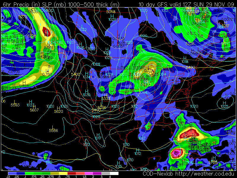 Slushy Snow for the Sunday after Thanksgiving? The GFS model valid Sunday morning at 6 am is hinting at rain changing to snow the weekend after Thanksgiving - probably rain on Saturday, Nov. 28, mixing with and changing to wet snow on Sunday, the 29th. It's early, but you may want to consider leaving the relative's house a little earlier than scheduled. We'll keep you posted.
Paul's Outlook for the Twin Cities
Today: Clouds giving way to intervals of sun, mild for late November. Winds: W/SW 5-10. High: near 50
Tonight: Partly cloudy, frosty. Low: 29
Saturday: Fading sun, breezy - clouds increase PM hours. High: 53
Sunday: Cloudy, a period of rain late Sunday and Sunday night. High: 49 (wet snow possible for the MN Arrowhead).
Monday: Windy and cooler with sprinkles/flurries. High: 44
Tuesday: Chilly, gray with snow showers/flurries, probably no accumulation. High: 39
Wednesday: A mix of clouds and sun, chilly. High: 36
Thanksgiving: Dry, unusually sunny for November. High: 39
Friday: Partly sunny, breezy and milder. High: 45
Saturday (Nov. 28). A period of rain. High: 44
Sunday (Nov. 29). Rain, possibly changing to wet snow. High: 38 (falling)


No comments:
Post a Comment