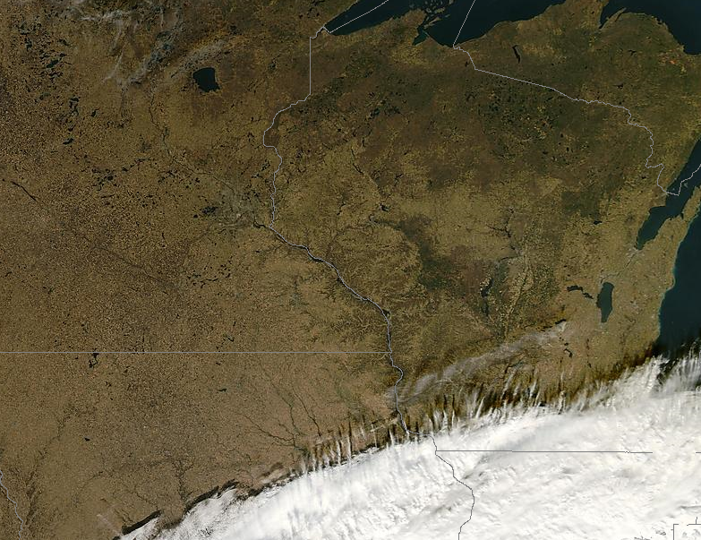
Severe Clear. This is an ultra-high resolution NASA image from the low-orbiting "Aqua" weather satellite, showing crystal clear skies over most of Minnesota and Wisconsin, a sharp cut-off to the cloud line from Des Moines to the Quad Cities and Milwaukee. This is a "true color" image, retouched to simulate reality. Yes, the ground is now brown (after our widespread freezes in recent weeks). Not much green showing up on this map!
 When Alaskans shiver, Minnesotans (usually) rejoice. There's an interesting correlation between what's happening in Alaska, and subsequent weather observed over Minnesota. It's not foolproof (there are exceptions) but USUALLY, when Alaska is bitterly cold during the winter months, Minnesota temperatures tend to trend above average, with more of a Pacific component to our prevailing winds. I'll let you know when Alaska warms up - that's when we need to watch out for a brutal slap of Siberian air!
Saturday still appears to be the nicer day of the weekend, enough sun for low 50s over parts of Minnesota. A southerly fetch pushes more (thick) clouds back into the state Sunday, and a little light rain or drizzle may result. Northwesterly winds return next week, highs dipping into the 30s by the latter half of next week. It will be cold enough for snow by Thanksgiving Day, but with a west/northwest wind flow I don't see any significant moisture - we won't have the ingredients necessary for a big snow or ice storm next week. So far so good for Thanksgiving travel, I'm cautiously optimistic we won't be tracking any epic storms next week (at least not here in the Upper Midwest). The Pacific Northwest has been getting the brunt of recent storms, and conditions are ripe for "cyclogenesis" (ie. storm formation) on the east coast next week. Rain is likely from Washington D.C. north to New York and Boston, and I could see some rain-delays at airports in the northeast, especially the latter half of next week.
 My calendar must be malfunctioning. Looking at the current snowcover map you'd swear it's October 18, not November 18. Notice an utter lack of snow on the ground anywhere east of the Mississippi. Normally, by mid November, you'd see a few inches of snow piling up over northern Michigan and interior New England. This year: nothing...
 Spits and "spritzes" of rain. I think "spritz" is an Amish term. I've never seen a good definition, but I place a spritz somewhere between a sprinkle and a light shower - just enough rain to put your windshield wipers on intermittent. The latest 84 hour GFS model prints out very light amounts south/east of the Twin Cities (under .05") - most of that coming late Wednesday night and Thursday morning. Some .25" amounts are predicted east of La Crosse, WI.
 Pretty quiet for November. The Pacific Northwest has seen heavy rain, 40-65 mph. wind gusts, and 1-3 feet of mountain snows, but this epic parade of Pacific storms has been focused on Seattle and Portland, the storms weakening rapidly as they cross the Rockies. You can see the (weakening) circulation of the Middle Mississippi storm, pushing northeast toward Chicago and Detroit, capable of brushing Minnesota with clouds - maybe a few light sprinkles or showers by Thursday.
 A minor fly in the ointment? The latest GFS model run shows Sunday's front stalling over far southeastern Minnesota Monday and Monday night. A cold rain may fall south/east of the Twin Cities (better chance for Rochester and La Crosse). There may be just enough cold air aloft for a rain/snow mix Monday night, but it's too early to speculate on specific timing and possible amounts. Right now it does NOT look like a major snowfall for southeastern Minnesota.
 Thanksgiving week preview. Here is the raw (GFS) model data for the latter half of next week. Check out "total precipitation" and the lack of significant moisture around the holidays. In general a temperature of 0 (Celsius) or colder at 850 mb (about 3,000 to 4,000 feet) is required for significant snow. Temperatures at that altitude will be marginally cold enough, but a lack of moisture should mean a lack of major storms for Thanksgiving and "Black Friday" shopping expeditions. We're not quite out of the woods - yet - but so far, so good.
Tuesday Alamanc for the Twin Cities. High: 48. November precipitation so far: .15" (.97" drier than average, to date).
Paul's Outlook for the Twin Cities
Today: Fading sun, clouds increase and thicken during the day. Winds: E 5-10. High: 47
Tonight: Mostly cloudy, a few sprinkles can't be ruled out. Low: 35
Thursday: Mostly cloudy and damp - a sprinkle or shower (but most of the day should be dry). High: 44
Friday: More clouds than sun, probably dry. High: 48
Saturday: Nicer day of the weekend. Intervals of sun, unseasonably mild. High: 51
Sunday: Gray and drab with drizzle, maybe a few hours of light rain. High: 47
Monday: Partial clearing, a drier day (cold rain or rain/snow mix for far southeastern MN). High: 43
Tuesday: Closer to average, becoming partly sunny and brisk. High: 38


No comments:
Post a Comment